Approved:
                     -----------------------------------------------
                     Andreas Nathues                                      Date
                     Experiment Team Lead


                     -----------------------------------------------
                     Steven P. Joy                                        Date
                     Dawn Science Center Manager


                     -----------------------------------------------
                     Christopher T. Russell                               Date
                     Dawn Principal Investigator


                     -----------------------------------------------
                     Michael F. A�Hearn                                   Date
                     PDS Lead Node (SBN) Manager
Table of Contents
1.4. Acronyms and Abbreviations
1.9. Relationship to Other Dawn Archives
2.5. Operational Considerations
3.3. Data Processing and Production Pipeline
3.3.1. EDR (Level 1a) Data Production Pipeline
3.3.2. RDR (Level 1b) Data Production Pipeline
4.3. Volume Labeling and Identification
4.4.1. Instrument Team Validation
4.4.2. Science Team Validation
5.3. CATALOG Directory Contents
5.4. DOCUMENT Directory Contents
5.5. DATA (Standard Products) Directory Contents and Naming Conventions
5.5.2. DATA Sub-Directory Naming Convention
5.5.3. File Naming Conventions
6.1. FC EDR Image File Structure
6.2. FC RDR Image File Structure
6.3. EDR and RDR Data Product Format Description
A.1. EDR (Level 1a) Data Product Label
Appendix B. Support Staff and Cognizant Persons
This document describes the contents and types of archive volumes belonging to all of the VIR NASA level 1 (CODMAC levels 2 and 3) data sets. This includes detailed descriptions of the data formats to allow users to read the data products.
   ===========================================================================
   Table 1: Distribution List
   Name                       Email
   ===========================================================================
   A. Nathues                [email protected]
   H. Sierks                 [email protected]
   P. Gutierrez-Marques      [email protected]
   I. Hall                   [email protected]
   I. Büttner                [email protected]


   M. A'Hearn                [email protected]
   S. Joy                    [email protected]
   J. Mafi                   [email protected]
   C. Raymond                [email protected]
   C. Russell                [email protected]
   ===========================================================================
   ===========================================================================
   Table 2: Document Change History
   Change                 Date          Affected Portions
   ===========================================================================
   Boilerplate  Draft   02 Nov 2007        All

   First Draft          25 Jun 2009        All

   Second Draft         21. Oct 2009       All

   Third Draft          21. July 2010      All

   Fourth Draft         28. Aug 2010       All

   Fifth Draft          1. Oct 2012        Removed VIR references from section 2.3
                                           Added information on 2.4 w.r.t. windowed mode
                                           and user-defined windows
                                           Added information on 6.1. w.r.t. windowed mode
                                           Added information on 6.3 w.r.t. the
                                           relationship between data object pointers
                                           and image object.

   Sixth Draft          8.Mar 2013         Addressed issues reported in VSA/VSS/VSH
                                           delta review.

   Version 1.0          17.Oct 2013        Sections 1, 3-6

   Version 1.1          16.Dec 2013        Section 5.2

   Version 1.2          17.Feb 2016        Sections 1.6, 3.1, 5.5.2, 6.3

   Version 1.3          15.Aug 2016        Sections 4.3 Volume naming convention
   ===========================================================================
   ===========================================================================
   Table 3      : TBD Items
   Item           Section               Pages
   ===========================================================================

   ===========================================================================
   ===========================================================================
   Table 4:  Acronyms and Abbreviations
   Acronym      Definition
   ===========================================================================
   ASCII       American Standard Code for Information Interchange
   CDROM       Compact Disc, Read Only Memory
   CODMAC      Committee on Data Management and Computation
   DSC         Dawn Science Center
   DSDb        Dawn Science Database
   DSN         Deep Space Network
   DVD         Digital Versatile Disc
   EDR         Experiment Data Records
   FC          Framing Camera(s)
   FLTOPS      JPL Multi-mission Flight Operations
   Gb          Gigabit(s)
   GB          Gigabyte(s)
   GRaND       Gamma Ray and Neutron Detector
   HAMO        High Altitude Mapping Orbit
   ISO         International Standards Organization
   JPL         Jet Propulsion Laboratory
   LAMO        Low Altitude Mapping Orbit
   NSSDC       National Space Science Data Center
   PDB         Project Database
   PDS         Planetary Data System
   RDR         Reduced Data Records
   RMOC        Remote Mission Operations Center
   SAMO        Survey Altitude Mapping Orbit
   SBN         Small Bodies Node
   ST          Science Team
   SIS         Software Interface Specification
   TBD         To Be Determined
   UCLA        University of California, Los Angeles
   VIR         Visual and Infrared Mapping Spectrometer
   ===========================================================================
Archive - An archive consists of one or more Data Sets along with all the documentation and ancillary information needed to understand and use the data. An archive is a logical construct independent of the medium on which it is stored.
Archive Volume - A collection of files formatted according to the PDS Archive Volume standards. This collection may be electronic or stored on a PDS approved physical media such as DVD or CDROM.
Archive Volume Set - A collection of one or more Archive Volumes used to store a single Data Set or collection of related Data Sets.
Catalog Information - High-level descriptive information about a Data Set (e.g., mission description, spacecraft description, instrument description), expressed in Object Description Language (ODL), which is suitable for loading into a PDS catalog.
Data Product - A labeled grouping of data resulting from a scientific observation, usually stored in one file. A product label identifies, describes, and defines the structure of the data. An example of a Data Product is a planetary image, a spectral table, or a time series table.
Data Set - A Data Set is a collection of Data Products from a single instrument that have a common data processing level, together with supporting documentation and ancillary files.
Standard Data Product - A Data Product generated in a predefined way using well-understood procedures, processed in "pipeline" fashion. Data Products that are generated in a non�standard way are sometimes called special Data Products.
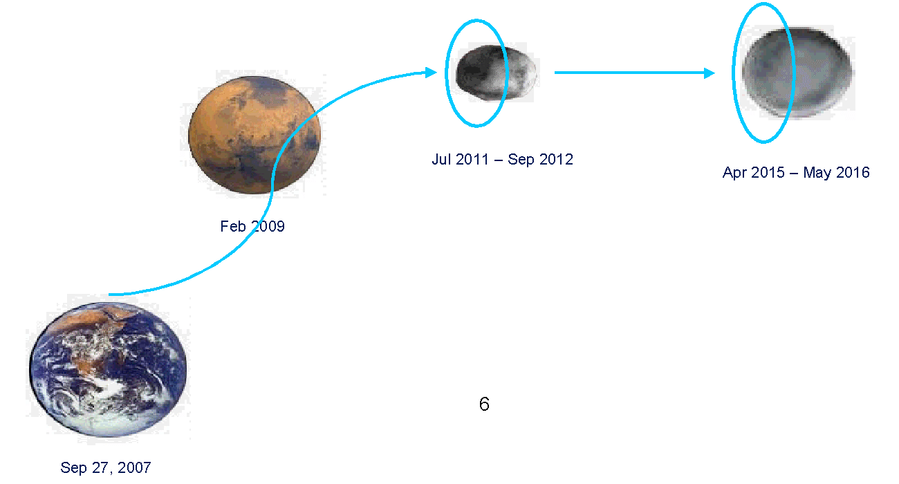
The overall scientific goal of the Dawn mission is to achieve an understanding of the conditions and processes during one of the solar system�s first epochs. It achieves this by flying to and orbiting the main belt asteroids (protoplanets) Ceres and Vesta, orbiting Vesta for a period of not less than seven months and Ceres for not less than five months. At least one and a half months at Vesta are below a mean altitude of 200km, and at least one month of Ceres is below a mean altitude of 700km.
The launch period for Dawn opened on September 26, 2007 and the spacecraft launched on September 27, 2007 at 11:34:00.372 UTC. Dawn is an ion-propelled spacecraft capable of visiting multiple targets in the main asteroid belt. Dawn arrived at Vesta on July 16, 2011, and departed Vesta on September 5, 2012. In the ISB navigation plan, Dawn arrives at Ceres on March 29, 2015, where Dawn orbits until the end of the baseline mission. Dawn flew by Mars in February 2009 en route to Vesta.
The Dawn spacecraft carries three science instruments. The data from these three instruments, when combined, provides information to characterize Vesta and Ceres. The instrument suite consists of redundant framing cameras (FC1 and FC2), a visible and infrared mapping spectrometer (VIR), and a gamma ray and neutron detector (GRaND). In addition to these instruments, radiometric and optical navigation (OpNav) data are used to determine the gravity field and thus bulk properties and internal structure of the two bodies.
Figure 1 Overview of Dawn Mission.
Dawn is an asteroid mapping mission. Each asteroid encounter is nominally sub- divided into three mapping phases, each at different altitudes, and each with different science objectives and primary experiments. Shortly after orbit capture the spacecraft enters into a survey altitude mapping orbit where the VIR instrument is primary. This phase is relatively short, lasting for only 6-7 orbits. Global spectroscopy data and low resolution global image mosaics are acquired during these phases at each asteroid. After survey, the spacecraft is maneuvered into a high altitude mapping orbit (HAMO) where the FC instrument is primary. Medium resolution global stereo imaging is performed at this altitude (950 km Vesta, 1950 km Ceres) while local high resolution spectroscopy data is acquired. Finally, the spacecraft proceeds to the low altitude mapping orbit (LAMO) where the GRaND and gravity experiments will collect their prime data and additional, local, high resolution imaging and spectroscopy data will be acquired. On asteroid approach, all of the instruments perform in-flight calibrations and acquire data that will be used to characterize the hazards of the near asteroid environment (dust) and search for moons.
Chapter 2 describes the FC instrument, including its primary science objectives, detectors, electronics, optics, operation, and calibration.
Chapter 3 describes the data sets, data volume, data processing and production, data flow, and scientific data validation.
Chapter 4 describes the archive volume generation, volume naming conventions, production, and PDS peer review.
Chapter 5 describes the PDS archive volume structure, the contents of each directory, and the various file naming conventions.
Chapter 6 describes the format of the EDR and RDR data files
Appendix A provides example PDS labels for the data files, index and geometry tables, and an example document label.
Appendix B lists the support staff and cognizant personnel associated with the archive generation and validation.
This specification applies to all archive volumes containing FC data products for the duration of its mission.
Higher level products, such as, for example, mosaics, and stereo images, are foreseen but will be defined and detailed later on.
Archive Description Documents
Planetary Science Data Dictionary Document, August 28, 2002, Planetary Data System, JPL D-7116, Rev. E
Planetary Data System Standards Reference, March 20, 2006, Version 3.7. JPL D-7669, Part 2.
Planetary Data System Archive Preparation Guide, August 29, 2006, Version 1.1. JPL D-31224.
Dawn Science Data Management Plan, May 3, 2007, DAWN-31-4032, JPL D-25901, Rev. A.
Instrument Papers or other technical documents
Dawn Framing Camera FM Housekeeping Calibration Information, K.-Michael Aye, MPS report DA-FC-MPAE-TN-033 (21 June 200 7).
Calibration Pipeline, Schröder, S.E. and P. Gutierrez-Marques, MPS report DA-FC-MPAE-RP-272 (28 Jan 2008).
Dawn Mission to Vesta and Ceres, C.T. Russell, F. Capaccioni, A. Coradini, M.C. De Sanctis, W.C. Feldman and 11 others, Earth, Moon and Planets 101, 65-91, 2007.
This specification is useful to those who wish to understand the format and content of the FC PDS data product archive collection. Typically, these individuals would be scientists, data analysts, or software engineers.
FC is a multi-spectral high resolution framing camera. It can take images in a broadband visible filter and 7 narrow band filters ranging from 450 to 980 nm with an IFOV of 96 millirad x 96 millirad.
The camera is composed by a Camera Head and an Electronic Box. The first one contains a 1024 x 1024 front lit CCD with its proximity electronics and its radiator, the filter wheel, the lens barrel, a baffle and the protective front door. The electronic box houses the power converter module, the mechanism controller unit and the data processing unit.
The camera is autonomously controlled by the data processing unit, which is in charge of all the communications with the spacecraft and controlling all the other subunits.
The architecture of the camera makes it suitable for various scientific and operational purposes. The science objectives of the FC are the characterization of Vesta and Ceres by means of their most relevant parameters:
The optics of the Framing Camera consists of an F/8 rad-hard refractive lens system, a set of filters, and a baffle in front of the lens system. The 5.5° x 5.5° field of view is achieved with a focal length of 150 mm and aperture of 19 mm. The lens system with baffle is mounted in front of the CCD by means of a lens barrel.
Between the lens barrel and the CCD lies the filter wheel with its selection of filters as shown in the graph below.
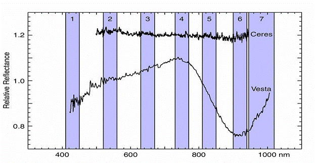
Figure 2: Location of the bandpasses within the spectrum of Vesta and Ceres. See Table 7 for a correspondence between bands and filter numbers.
The CCD has a 1024x1024 sensitive area with 14 µm pitch, representing a field of view of 93 µrad per pixel. The exposure time can be commanded from 1 ms to several thousands of seconds. The image information collected in the sensitive area during the exposure time is transferred on a fast mode to the shielded area in 1.32 ms. Then the image information is amplified and read at a 1 Mpixel/s rate and transferred to the data processing unit.
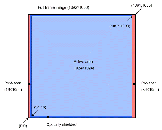
Figure 3: Active 1024x1024 pixel region on the whole CCD
The Framing Camera contains mainly four electronic subsytems, the Data Processing Unit (DPU), the Mechanism Controller Unit (MCU), the Power Converter Unit (PCU) and the Front-End Electronics (FEE).
The Data Processing Unit controls the camera as a whole and each of the subsystems, decodes the ground commands and transmits scientific and engineering data to the spacecraft. It also contains the mass memory to store the images in the time since they are acquired until they are transmitted to the spacecraft for forwarding to ground. Finally, it also performs the necessary on-board processing of the images, discarding non-relevant parts of the frame and compressing the images to reduce the data volume to be transmitted to ground.
The Mechanism Controller Unit commands the front door and filter wheel mechanisms and reads out the associated temperature and position sensors.
The Power Converter Unit supplies the camera with the voltages needed for correct operation. It is fed from the 28 V unregulated power bus and provides
The Framing Camera can be operated to acquire a single image per command. This mode of operation requires the most time for sequence generation and for execution because it has to be verified that an image acquisition is finished before commanding a new one.
By using higher level UDPs it is possible to acquire several images with one command at a higher acquisition rate. The currently fastest rate is about one image every 4 seconds with no need for adding any margin on top of it.
The instrument can acquire several kinds of images as listed in the table below.
   ===========================================================================
   Table 5: Image acquisition Modes
   Mode             Decription
   ===========================================================================
   Test Pattern     1024x1024 pixel with grayscale from 0 DN to 16383 DN

   Full-Full-Frame  Readout of the whole 1092x1056 pixel CCD

   Full-Frame       Readout of the active 1024x1024 pixel region plus optical
                    shield regions

   Windowed Mode    Readout of up to 10 user-defined windows within the 1024x1024
                    pixel active area of CCD. The image is originally acquired
                    as a Full-frame and then cropped in different windows, all
                    of them with the same filter and exposure time. The windows
                    are defined by issuing commands prior to the acquisition of
                    the image, and these windows remain valid until a new
                    definition is sent.
   ===========================================================================
The framing cameras mass memory is 1GB. This is enough to store around 450 uncompressed full images each 2.2 MB. With lossless compression this number grows to 800 or even more images.
The second limiting factor for the number of images that can be acquired in a certain time is the maximal image acquisition rate. When no filter wheel changes are required this is approximately 1 image every 4 seconds. This time is needed for memory allocation, readout of the CCD, writing the image to memory.
Typical times for processing of the images are one minute to compress with a compression ratio of ~2 and another minute to stream the compressed image into the space craft recorder at a transmission rate of the MILbus of 150 kb/s.
The FC1 CCD is known to be affected by residual, or extra charge. Extra charge is charge that is already present on the CCD before the start of an exposure, and is caused by insufficient draining by the anti-blooming gates. It may occur when imaging an extended source, with its intensity depending on the radiant flux. It was first identified in a very brief (1 msec) clear filter exposure of the inside of an integrating sphere acquired on 8 March 2006. The extra charge was found to be variable over the active area, and to differ significantly from pixel to pixel. At the particular radiant flux used in the experiment (F1 charge rate 6.7x10⁴ DN s-1) it amounts to several hundreds of DN for some pixels. It is unknown how the extra charge scales to the radiant flux level expected at Vesta, which is two orders of magnitude higher than the flux achieved in the experiment. The FC2 CCD was exposed to much lower flux levels than FC1 in the integrating sphere on 12 August 2005, and extra charge was absent. The FC1 images did show traces of extra charge at these low levels. Yet it is possible that at the much higher Vesta flux the FC2 will also be found to be affected. The residual charge is also temperature dependent, which might have an impact on the temperature to operate at Vesta and Ceres.
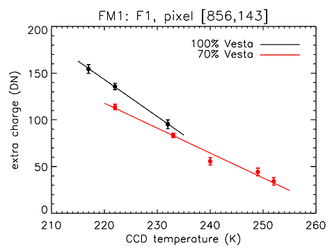
Figure 4: Temperature dependency of extra charge
The FC has 8 filters at its disposal, numbered from F1 to F8. F1 is a broadband (clear) filter, sensitive in the wavelength interval from 400 to 1100 nm peaking at 700 nm. The narrow-band color filters are of the interference type, and have the following effective wavelengths:
   ===========================================================================
   Table 6:      FC Filter Parameters
   Filter   Band #   Color      Effective         FWHM [nm]
                                wavelength [nm]
   ===========================================================================
   F2         2       Green        555              +15, -28
   F3         4       Red          749              +22, -22
   F4         6       NIR          917              +24, -21
   F5         7       NIR          965              +56, -29
   F6         5       NIR          829              +15, -18
   F7         3       Red          653              +18, -24
   F8         1       Blue         438              +10, -30
   ===========================================================================
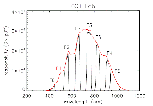
Figure 5: The FC1 absolute responsivity for the different filters as determined from the lab calibration.
The optical design was developed by Kayser-Threde based on the missions requirements. The telecentric four-lens design is derived from a triplet with split third lens to allow telecentricity in image space. The design is optimized for low distortion.
The chromatic variation of the focal plane was compensated for by varying the filter thickness with filter central wavelength. Chromatic aberration was compensated for by the choice of glasses used for the lenses, crown glass with positive refractive power in the first lens followed by two flint lenses of negative refractive power and a forth with positive refractive power. Spherical aberration is corrected with an aspherical first surface.
To maintain a fixed focal length under changing temperatures, the two central lenses are mounted in an inner barrel with a different thermal expansion coefficient than the main barrel. The resulting differential movement with changing temperatures maintains a constant focal plane location within a range of 30 µm.
The optical design required an adequate back focal length to accommodate the filter wheel mechanism inside the camera head, between the lens system and the CCD. The filter wheel transports the eight filters with the lower filter surface at a constant clearance from the CCD. The overall spectral range of the optical system is 400-1050 nm. The band passes are obtained by a multilayered, thin film deposition on the front and back surfaces of silica (Suprasil) substrates. Filter dimensions are 20 mm by 20mm, with the thickness specified for the band pass.
   ===========================================================================
   Table 7: Camera Optics Parameters
   Parameter              FC1          FC2
   ===========================================================================
   Focal Length, mm      150.0        150.0
   f/ratio                f/8          f/8
   IFOV, µrad/pixel       93.3         93.3
   Field of view, °
     Cross-track          5.46         5.46
     Along-track          5.46         5.46
   ===========================================================================
   ===========================================================================
   Table 8: Onboard Software Version
   Version      Loaded FC1             Loaded FC2
   ===========================================================================
   3.01.05      Prior to Launch       Prior to Launch
   3.03.02      DC014 2008-04-02      DC014 2008-04-01
   3.04.02      DC034 2009-12-02      DC034 2009-12-01
   3.05.01      DC048 2011-03-16      DC048 2011-03-15
   3.09.03      DC072 2014-06-23      DC074 2014-08-19
   ===========================================================================
The FC has been calibrated using the results of laboratory and in-flight measurements. The lab measurements were acquired at the Max Planck Institute for Solar System Research, and were aimed at determining the dark current and the absolute photometric response in each of the filters. Flat fields were acquired by imaging the inside of an integrating sphere.
The in-flight measurements, acquired during the Initial Check-Out campaign in the months after launch, focused on characterizing the dark current and geometric distortion (through observation of star fields), and validating the lab radiometric calibration (photometric standard stars). The calibration pipeline is described by [Schröder & Gutierrez-Marques 2008].
Dark current, and the associated emergence of bad pixels, and the amount of geometric distortion will continue to be monitored during bi-annual check-outs. Images acquired during the Mars Gravity Assist will enable us to validate the lab flat fields. A better understanding of the FC flat field response and in-field stray light characteristics may require reprocessing of data in the future.
Two data sets will be delivered for each mission phase: one raw (EDR) data set, and one calibrated (RDR) data set.
   ===========================================================================
   Table 9: PDS Data Sets
   Data Set ID                            Standard Data    Data Set Description
                                          Product ID
   ===========================================================================
   DAWN-CAL-FC1-2-EDR-CALIB-IMAGES-V1.0   FC_IMAGE         FC1 Raw L1A (EDR)
                                                           calibration images

   DAWN-X-FC1-2-EDR-CRUISE-IMAGES-V1.0    FC_IMAGE         FC1 Raw L1A (EDR)
                                                           cruise images

   DAWN-CAL-FC2-2-EDR-CALIB-IMAGES-V1.0   FC_IMAGE         FC2 Raw L1A (EDR)
                                                           calibration images

   DAWN-X-FC2-2-EDR-CRUISE-IMAGES-V1.0    FC_IMAGE         FC2 Raw L1A (EDR)
                                                           cruise images

   DAWN-M-FC2-2-EDR-MARS-IMAGES-V1.0      FC_IMAGE         FC2 Raw L1A (EDR)
                                                           Mars flyby images

   DAWN-A-FC2-2-EDR-VESTA-IMAGES-V1.0     FC_IMAGE         FC2 Raw L1A (EDR)
                                                           Vesta images

   DAWN-A-FC2-2-EDR-CERES-IMAGES-V1.0     FC_IMAGE         FC2 Raw L1A (EDR)
                                                           Ceres images

   DAWN-X-FC1-3-RDR-CRUISE-IMAGES-V1.0    FC_IMAGE         FC1 Calibrated L1B (RDR)
                                                           cruise images

   DAWN-X-FC2-3-RDR-CRUISE-IMAGES-V1.0    FC_IMAGE         FC2 Calibrated L1B (RDR)
                                                           cruise images

   DAWN-M-FC2-3-RDR-MARS-IMAGES-V1.0      FC_IMAGE         FC2 Calibrated L1B (RDR)
                                                           Mars flyby images

   DAWN-A-FC2-3-RDR-VESTA-IMAGES-V1.0     FC_IMAGE         FC2 Calibrated L1B (RDR)
                                                           Vesta images

   DAWN-A-FC2-3-RDR-CERES-IMAGES-V1.0     FC_IMAGE         FC2 Calibrated L1B (RDR)
                                                           Ceres images
   ===========================================================================
The DSC captures all of the payload instrument telemetry frames as binary files after the data have been cleaned up in the post-pass processing (reconstructed level-0 data). Post-pass processing is completed with 8 hours of each pass and typically is able to fix minor forms of data corruption (partial packet reconstruction, dropped time tags, etc.). These files are inventoried within the Dawn Science Database (DSDb) and made available to the teams for download at any time. The DSC prepares the documentation and metadata required in order to submit these products to the PDS to be saved (rather than archived). The PDS documentation threshold for saved data sets is substantially lower than for archived products. The raw decoded frames are not considered to be useful for the general science community but the bits will be preserved in their rawest form. The DSC will submit the telemetry frames to the PDS Small Bodies Node (SBN) within a week of the end of each science phase. All level-0 data products are created with PDS "minimum" labels. Each level-0 data file contains the CCSDS (Consultative Committee for Space Data Systems) packets for a single APID (Application Process Identifier).
The Doppler Tracking data are used by the NAV and Gravity Science teams and do not flow into the TDS (Telemetry Data Server). These data flow from the DSN into the OSCAR-X system where they are accessible to the gravity team at JPL. Since these data do not flow directly into the DSC, the DSC staff will manually retrieve them from OSCAR-X and load them into the DSDb. Gravity Science investigators that are not at JPL will use the DSDb to retrieve the level-0 data for their analysis. This process is described in the operational interface agreement (OIA-DSC-409) between the Gravity Science Team and the DSC. Unlike the decoded frames, the level-0 Doppler Tracking data are archived with the PDS. DSC prepares these data for archive and submits them to the PDS SBN at the same time as the level-1a data products from the payload instruments.

Figure 6: Dawn Science Data Flow. SPAA elements and products are outlined with solid black lines, MOS components with dotted lines, and PDS components with dashed lines.
The data reduction pipeline is implemented in a tailored application called Calliope. The input to the application comprises a set of images in PDS format, a configuration file and various reference data files.
The PDS files to be fed into the pipeline are the direct output of Trap, the so-called Level 1a of image processing, where the images are uncompressed and reconstructed back to image format but the value of the pixel is a plain digital number.
The configuration file, also called mission calibration description file, is an XML file describing the different operational slots and the reference files to be used for the calibration of the images in each one. It also contains some constants for the calibration image, such as the radiometric calibration coefficients, dark current curve and any other constant that can be applied to all the pixels in the sensor.
The reference files are typically synthetic images that represent the distribution of a magnitude over all the pixels in the sensor, such as the dark current generation rate or the sensitivity of the pixel. These files help correcting the differences among pixels to provide a measurement of the real light flux as accurate as possible. Being Dawn a long term mission, these images, as the related constants, are bound to change throughout the mission and the configuration file captures this effect by matching each reference file and constant to its corresponding time of application.
The Instrument Teams retrieve the reconstructed Level-0 data from the DSDb and use it to produce the Level-1a (raw, reformatted) data sets. The raw telemetry data are decompressed, decoded, and formatted into scientifically useful data structures. These products, along with their required PDS documentation, form the level-1a data sets (EDRs). The Instrument Teams extract the reconstructed spacecraft ephemeris and pointing data (SPICE kernels) from the DSDb and use these data to compute the various geometry data that are included in the PDS labels associated with each data product. The Instrument Teams are required to submit the PDS-labeled EDRs to the DSDb within 7 days after the reconstructed data are made available to the teams (see OIA-DSC-406). These data are then available to the rest of the Science Team for validation and preliminary analysis. If any problems are discovered during validation or analysis, new products are produced by the FC team and delivered to the DSC for use by the Science Team and eventual archive (see schedule) by the PDS. The FC team also generates PDS catalog files and other documentation (activity reports, instrument performance reports, calibrations, etc.) and provides these files to the DSC for the internal distribution and archive.
After the data are validated by the Dawn Science Team, the DSC packages the data, catalog files, and documentation into PDS-compliant archive data volumes, one volume for each data set according to PDS volume organization standards (JPL-D-7669). The DSC is responsible for the creation of the PDS required files associated with archive volumes (AAREADME.TXT, VOLDESC.SFD, etc.), including the index table. The DSC then delivers the volumes to the PDS SBN in accordance with the SBN standard data delivery practices at the time of each delivery. Presently, the PDS SBN accepts volumes delivered electronically, on CDROM, and on DVD-R. EDR data volumes are to be delivered to the PDS SBN for peer review within 90 days of the end of each science phase (Approach, Survey, HAMO, LAMO, etc.). The DSC is responsible for following the archive submissions through the PDS peer review process until the data are finally accepted into the PDS archive. The Instrument Teams will support the DSC during this PDS process by providing any additional documentation that is requested by the PDS peer review panel.
Additional data processing is performed by the FC team to produce calibrated level 1b (RDR) data products (radiometrically corrected spectra). The FC team produces the processed products using the archived EDR data sets. The RDR data products are submitted to the DSDb within a few months of the receipt of the corrected telemetry by ground data system. If during the course of the mission an improved calibration becomes available, the FC team may choose to update the data in the DSDb using the latest version of the calibration. The FC team is not obligated to provide updated RDR data products and any such resubmission would be negotiated with the Science Team. The DSDb system supports the resubmission of data sets.
The DSC has the same roles and responsibilities with respect to the generation of PDS archive compliant volumes for the RDR data sets as it does for the EDR data sets. Final RDR data volumes are publicly released by the PDS SBN within 6 months after asteroid departure. In order to support this schedule, peer review copies of the archive volumes will normally be delivered to the SBN 2 months prior to the final data release. The DSC and FC Teams will support the PDS peer review process of the RDR data sets in the same manner as the EDR data sets. Peer review liens will be addressed in time to support the public release date. Final (corrected) archive volumes will be delivered to the SBN two weeks prior to the public release.
   ===========================================================================
   Table 10: Data Release Schedule
   Data Product      Provider      Mars          Vesta                      Ceres
   Level 0             DSC         Apr 2009    Oct 2011 to Apr 2012     Mar 2015 to Aug 2015
   EDR - Level 1a      FC/DSC      Oct 2009    Dec 2011 to Jun 2012     May 2015 to Sep 2015
   RDR - Level 1b      FC/DSC      Oct 2009    Aug 2012                 Jan 2016
   Derived Data        FC          Apr 2010    Feb 2013 to Aug 2014     Jan 2016
   ===========================================================================
* Assumes current project schedule (arrival and departure dates)
This chapter describes the format of FC standard product archive volumes. Data that comprise the FC standard product archives will be formatted in accordance with Planetary Data System specifications [Planetary Science Data Dictionary, 2008; Planetary Data System Archive Preparation Guide, 2006; PDS Standards Reference, 2007].
The DSC collects the data files and labels provided by the FC team onto archive volumes. Each archive volume contains all FC data available for the time interval covered by the archive volume. Once all of the data files, labels, and ancillary data files are organized onto an archive volume, the DSC adds all of the PDS required files (AAREADME, INDEX, ERRATA, etc.) and produces the physical media.
Disk formats for the archive volumes will conform to the PDS standard for the applicable media. At present, the plan is to archive FC data in online data volumes that are delivered to the SBN electronically. Although the volumes will be electronic, they will comply with the same volume organization standards that PDS formerly used to describe physical volumes on DVD or CDROM media.
Each FC data set will be archived on a separate PDS volume. The volume naming convention is:
DWNp(s)FCn_lx
where:
p - mission phase (X = cruise; M = Mars; V = Vesta; C = Ceres),
(s)� sub-phase, Ceres volumes only, (A=Approach, S = Survey, H=HAMO, L=LAMO)
n - Framing Camera number,
l - processing level (1A = EDR; 1B = RDR).
For example, the FC2 Mars EDR volume will be named DWNMFC2_1A or DWNCHFC2_1B for Ceres HAMO calibrated data.
Due to constraints on the length of VOLUME_ID's, the Calibration volumes will follow a slightly different convention. For these volumes the naming convention is:
DWNCALFCnl
where:
n - Framing Camera number,
l - processing level (1A = EDR; 1B = RDR).
For example, the FC1 Calibration volume will be named DWNCALFC11A.
The FC team will be making the following checks on the data, before submitting them to the DSC:
The Dawn Science Team has access to the FC EDR and RDR data sets for several months prior to their public release by the PDS. These are the data that the Science team uses for its initial data analysis and interpretation. Any data processing errors that are discovered through the use of the data are reported back to the FC team so that they can be corrected. In addition, the Science Team uses the same documentation that is later released to the PDS during its analysis. If any of the documentation is unclear, or if there are omissions in the documentation that hinder data analysis, these problems are reported back to the FC team so that they can be corrected.
The peer review panel consists of members of the instrument team, the DSC, and members of the PDS Small Bodies and Engineering Nodes, and at least two outside scientists actively working in the field of asteroid remote sensing science. The DSC is responsible for generating and delivering PDS-compliant volumes to the SBN. The PDS personnel are responsible for verifying that the volume(s) are fully compliant with PDS standards. The instrument team and outside science reviewers are responsible for verifying the content of the data set, the completeness of the documentation, and the usability of the data in its archive format. The peer review process is a two part process. First, the panel reviews this document and verifies that a volume produced to this specification will be useful. Next, the panel reviews a specimen volume to verify that the volume meets this specification and is indeed acceptable.
During the peer review process, the panel will normally identify errors or omissions in the archive documentation, problems with conformance with the PDS standards. All accepted peer review liens will be resolved prior to the public release of the data. Liens that require data product updates, or updates to the instrument or data set documentation will be addressed by the VIR team. Any problems identified with the volume format, volume documentation, index files, or other products produced by the Dawn Science Center will be corrected by the DSC. After the liens are resolved, the DSC will create and submit an updated archive volume to the PDS Small Bodies Node.
This section describes the contents of the FC standard product archive collection volumes, including the file names, file contents, file types, and organizations responsible for providing the files. The complete directory structure is shown in Appendix A. All the ancillary files described herein appear on each FC archive volume, except where noted.
The following files are contained in the root directory, and are produced by the DSC at UCLA. With the exception of the hypertext file and its label, all of these files are required by the PDS Archive Volume organization standards.
   ===========================================================================
   Table 11: Root Directory Contents
   File Name            File Contents                       File Provided By
   ===========================================================================
   AAREADME.TXT      This file completely describes            DSC
                       the Volume organization and contents
                       (PDS label attached).

   ERRATA.TXT        A cumulative listing of comments          DSC
                      and updates concerning all INST_ID
                      Standard Data Products on all INST_ID
                      Volumes in the Volume set published
                      to date.

   VOLDESC.CAT       A description of the contents of          DSC
                      this Volume in a PDS format readable
                      by both humans and computers.
   ===========================================================================
The following files are contained in the INDEX directory and are produced by the DSC. The INDEX.TAB file contains a listing of all data products on the archive volume and is described by a detached PDS label (INDEX.LBL). The index table, label, and index information (INDXINFO.TXT) files are required by the PDS volume standards. The index tables include both required and optional columns.
   ===========================================================================
   Table 12: Index Directory Contents
   File Name         File Contents                       File Provided By
   ===========================================================================
   INDXINFO.TXT      A description of the contents of        DSC
                     this directory

   INDEX.TAB         A table listing all INST_ID data        DSC
                     products on this volume

   INDEX.LBL         A PDS detached label that               DSC
                     describes INDEX.TAB

   GEOM_INDEX.TAB    A table containing Dawn geometry        DSC
                     information associated with the
                     data products (images) on this volume.

   GEOM_INDEX.LBL    A PDS detached label describing         DSC
                     GEOM_INDEX.TAB
   ===========================================================================
   ===========================================================================
   Table 13: Index Table (INDEX.TAB) Contents
   Column Name               Format     Units       Description
   ===========================================================================
   DATA_SET_ID                A40                   Unique identifier for the data
                                                    set of which the file is a part

   FILE_SPECIFICATION_        A80                   Complete path and file name
   NAME                                             relative to the volume root directory

   PRODUCT_ID                 A30                   PDS Product Identifier
                                                    (typically file name, minus extension
                                                    and version)

   VOLUME_ID                  A11                   Unique identifier for the volume
                                                      on which the file is located

   PRODUCT_CREATION_TIME      A24                   File creation date/time

   START_TIME                 A24                   File start time - UTC at
                                                      spacecraft

   STOP_TIME                  A24                   File end time - UTC at spacecraft

   EXPOSURE_DURATION          F10.3     msec        Time between the opening and
                                                    closing of the camera aperature.

  INSTRUMENT_ID               A3                    FC camera ID
   ===========================================================================
   ===========================================================================
   Table 14: Geometry Index Table (GEOM_INDEX.TAB) Contents
   Column Name               Format     Units       Description
   ===========================================================================
   INSTRUMENT_ID             A3                     FC camera ID

   IMAGE_TIME                A24                    Center time of the images

   FILE_SPECIFICATION_NAME   A80                    Complete path and file name
                                                    relative to the volume root
                                                    directory

   TARGET_NAME               A20                    Name of the observed target
                                                    (e.g. Mars, Vesta. Aldebaran)

   MISSION_PHASE_NAME        A30                    Identifier associated with the
                                                    Dawn mission phase

   OBSERVATION_NAME          A30                    Identifier associated with the
                                                    imaging session

   ORBIT_NUMBER              I4                     Orbit number (N/A unless target
                                                    = VESTA or CERES)

   COORDINATE_SYSTEM_NAME    A30                    Full name of coordinate system
                                                    to which state vectors are
                                                    referenced

   SPACECRAFT_ALTITUDE       F8.1       km          S/C altitude relative to the
                                                    target, kilometers (N/A for
                                                    calibration targets)

   TARGET_CENTER_DISTANCE    F8.1       km          Instrument distance to target
                                                    center, kilometers (N/A for
                                                    calibration targets)

   SLANT_DISTANCE            F8.1       km          Slant distance to the target
                                                    evaluated at the center pixel
                                                    of the image

   CENTER_LATITUDE           F7.3       deg         Center pixel planetocentric
                                                    latitude for the image/spectra
                                                    (N/A for calibration targets)

   CENTER_LONGITUDE          F8.3       deg         Center pixel planetocentric east
                                                    longitude for the image/spectra
                                                    (N/A for calibration targets)

   INCIDENCE_ANGLE           F6.2       deg         Incidence angle at the center of
                                                    the image/spectra

   EMISSION_ANGLE            F6.2       deg         Emission angle at the center of
                                                    the image/spectra

   PHASE_ANGLE               F6.2       deg         Phase angle at the center of the
                                                    image/spectra

   MINIMUM_LATITUDE          F7.3       deg         Minimum latitude of the image

   MAXIMUM_LATITUDE          F7.3       deg         Maximum latitude of the image

   WESTERNMOST_LONGITUDE     F8.3       deg         Minimum (westernmost) latitude
                                                    of the image

   EASTERNMOST_LONGITUDE     F8.3       deg         Maximum (easternmost) latitude
                                                    of the image

   SUB_SPACECRAFT_LATITUDE   F7.3       deg         Sub-spacecraft planetocentric
                                                    latitude (N/A for calibration targets)

   SUB_SPACECRAFT_LONGITUDE  F8.3       deg         Sub-spacecraft planetocentric east
                                                    longitude (N/A for calibration targets)

   SUB_SOLAR_LATITUDE        F6.2       deg         Sub-solar latitude on the target
                                                    in planetocentric coordinates

   SUB_SOLAR_LONGITUDE       F6.2       deg         Sub-solar longitude on the
                                                    target in planetocentric coordinates

   LOCAL_HOUR_ANGLE          F6.2       deg         Local hour angle at the center of
                                                    the image/spectra

   SC_TARGET_POSITION *      I8 (x3)    km          3 S/C position vector components
   (_X, _Y, _Z)                                     relative to the target in
                                                    planetocentric coordinates, kilometers

   SC_TARGET_VELOCITY *      F7.1 (x3)  km/sec      3 S/C velocity vector componenets
   (_X, _Y, _Z)                                     relative to the target in
                                                    planetocentric coordinates, kilometers

   RIGHT_ASCENSION           F8.4       deg         EME-2000 right ascension of the
                                                    center pixel in the image/spectra

   DECLINATION               F8.4       deg         EME-2000 declination of the center
                                                    pixel in the image/spectra

   TWIST_ANGLE               F8.4       deg         Angle of rotation about line from
                                                    camera to center pixel relative to
                                                    EME-2000

   CELESTIAL_NORTH_CLOCK_ANGLE  F7.3    deg         North celestial clock angle
                                                    evaluated at the center pixel of
                                                    the image/spectra

   SPACECRAFT_SOLAR_DISTANCE F8.1       km          S/C distance to the Sun center,
                                                    kilometers

   SC_SUN_POSITION_*         I8 (x3)    km          3 S/C position vector components
   (_X, _Y, _Z)                                     relative to the Sun in EME-2000
                                                    coordinates, kilometers

   SC_SUN_VELOCITY_*         F7.1 (x3)  km/sec      3 S/C velocity vector components
   (_X, _Y, _Z)                                     relative to the Sun in EME-2000
                                                    coordinates, kilometers
   ===========================================================================
The completed PDS catalog files in the CATALOG directory provide a top-level understanding of the Dawn/FC mission and its data products. The information necessary to create the files is provided by the FC team and formatted into standard template formats by the DSC. The files in this directory are coordinated with the data engineers at both the DSC and the PDS SBN.
   ===========================================================================
   Table 15: Catalog Directory Contents
   File Name             File Contents                     File Provided By
   ===========================================================================
   CATINFO.TXT          A description of the                      DSC
                        contents of this directory

   fc*_ds.cat           PDS  Data Set catalog                   FC Team
                        description of the data for
                        the XXX dataset

   dawninsthost.cat     PDS instrument host
                        (spacecraft) catalog description
                        of the Dawn spacecraft                    DSC

   fc*_instrument.cat   DS instrument catalog description       FC Team
                        of the FC instrument

   dawnmission.cat      PDS mission catalog description           DSC
                        of the Dawn mission

   personnel.cat        PDS personnel catalog description       FC Team
                        of FC Team members and other
                        persons involved with generation
                        of FC Data Products

   reference.cat        FC-related references mentioned         FC Team
                        in other *.CAT files

   ttt.CAT      PDS     catalog description of target             DSC
                        ttt (if provided for the volume)
   ===========================================================================
Archive documents are stored in the DOCUMENT directory branch of the archive volume. All documents are stored as PDF-A (archive PDF), and HTML versions. The HTML version consists of a "clean" HTML file (an HTML with minimal markup), with images saved as separate in separate files in some image format (e.g. JPEG, or PNG). The HTML constitutes the plain ASCII text version required by PDS standards. The DOCUMENT directory contains a separate sub-directory for each document in which all of the files associated with that document are located.
   ===========================================================================
   Table 16: DOCUMENT Directory Contents
   File Name              File Contents                       File Provided By
   ===========================================================================
   DOCINFO.TXT            A description of the contents of     DSC
                          this directory

   CALIBRATION_PIPELINE   Sub-directory containing the FC      FC Team
                          Calibration Pipeline description
                          document

   SCIENCE_PLAN           Sub-directory containing the Dawn    Dawn Project
                          Science Plan document

   SIS                    Sub-directory containing the FC      FC Team
                          Archive SIS (this document

   VESTA_COORDINATES      Sub-directory containing a
                          document describing the various
                          coordinate systems that have been
                          used for Vesta image products
                         (Vesta volumes only)
   ===========================================================================
The DATA directory contains the actual Data Products produced by the FC team.
Every file in the DATA path of an Archive Volume is described by a PDS label. Both text documentation files and image files have internal (attached) PDS labels. The attached label file for image files is an ASCII header section pre-pended to the images.
All archive volumes will have a separate sub-directory for each phase and observation. These sub-directories will be named according to the convention:
YYYYMMDD_XXXXXX
where:
YYYYMMDD is the date of the observation (4-digit year, 2-digit month, 2-digit day)
XXXXXX is the phase or observation name
For example, the sub-directory for the data from the FC2 Straylight Test performed 31 Mar 2009 (DOY 90) would be:
20090331_STRAYLIGHT
FC image files will be named according to the following convention:
FCxll_imageid_yydddhhmmssFnz.IMG
where:
FCx indicates the instrument
ll indicates the data processing level (e.g. 1A, 1B, etc.)
IMAGEID image id (7 characters, zero-padded)
yyddd indicates the image acquisition year/doy
hhmmss indicates the image SCET (UT)
Fn n indicates the filter number used in capturing the image (see Table 6)
z indicates the data file version (A-Z)
The images have an attached header, so the file consist of two parts: The image label followed by the image objects. Both, the EDR and RDR (level 1a and level 1b) products follow the same file structure. The labels contain the same keywords but number and size of the image objects may vary.
Depending on the image acquisition mode, each EDR will contain one or more image objects in the same file, all of them taken with the same filter and exposure time. Each of these images will be identified (see below) with a name, width and height, and the real CCD coordinates of the first row and column of the frame. In the cases where the image has been acquired in windowed mode with more than one window, there will be an additional 1024x1024 "IMAGE" frame with black background and all the small windows overlaid in their right positions within the CCD active area..
All image objects contain raw digital numbers of type "LSB_UNSIGNED_INTEGER".
RDR images are reduced to the size of the active area of the CCD of 1024x1024 pixel. All pervious image objects inside this region are merged into a single image object called "IMAGE". After the radiometric calibration the the DNs represent real physical units of type "PC_REAL"
A more detailed description of the format can be found in the following section.
===========================================================================
Table 17:FC Data Label Contents
Keyword Value Units Value Description
===========================================================================
PDS Version Keywords
PDS_VERSION_ID The version number of the PDS
standards documents that is valid
when a data product label is created.
Values for the PDS_VERSION_ID are
formed by appending the integer
for the latest version number to the
letters 'PDS'. Mandatory.
PDS_VERSION_ID = "PDS3"
LABEL_ REVISION_ NOTE Free-form unlimited length character
string providing information regarding
the revision status and authorship of a
PDS label. This should include the latest
revision date and author of the current
version, but may include a more complete
history. This element is required in all
Catalog labels and should be the second
element in the label.
The entry is optional but highly
recommended. Several fields are separated
by semicolons. Example values: "20080201, PGM,
DAWN FC V1.5"
File Characteristics
RECORD_TYPE Indicates the record format of a file. RECORD_TYPE
= "FIXED_LENGTH"
RECORD_BYTES Indicates the number of bytes in a physical file
record, including record terminators and
separators. When RECORD_TYPE = STREAM
(e.g. a SPREADSHEET), its value is set to
the length of the longest record in the file.
RECORD_BYTES = "512"
FILE_RECORDS Indicates the number of physical file records,
including both label records and data records.
LABEL_RECORDS Indicates the number of physical file records
that contain only label information. The number
of data records in a file is determined by
subtracting the value of LABEL_RECORDS
from the value of FILE_RECORDS.
Typically = 19 ... 27
FILE_NAME Provides the location independent name of a
file. It excludes node or volume location,
directory path names, and version specification.
To promote portability across multiple platforms,
PDS requires the FILE_NAME to be limited to a
27-character base name, a full stop (. period),
and a 3-character extension. Valid characters
include capital letters A - Z, numerals 0 - 9,
and the underscore character (_). The FILE_NAME
will be generated by TRAP at MPS.
See section 5.6.3 for naming convention
Pointers to Data Objects (Typically the PDS label has 20 ... 27 records.)
^IMAGE A regular array of sample values. Image
objects are normally processed with
special display tools to produce a visual
representation of the sample values. This
is done by assigning brightness levels or
display colors to the various sample values.
Images are composed of LINES and SAMPLES.
They may contain multiple bands, in one of
several storage orders.
The particulars of each of the
data objects are detailed in a
corresponding image object (see
below), including width, height
and coordinates of the first line
and sample.
Name of image object needs to end
with *_IMAGE. Other examples:
^FRAME_0_IMAGE, ^FRAME_1_IMAGE,
^FRAME_2_IMAGE, ^FRAME_3_IMAGE, ...
Typically = 21 ...28
^*_IMAGE (2nd pointer) Typically = 4000 ... 9000
^*_IMAGE (3rd pointer) Typically = 4000 ... 9000
^*_IMAGE (4th pointer) Typically = 4000 ... 9000
^*_IMAGE (5th pointer) Typically = 4000 ... 9000
^HISTORY A pointer to a part of the image
that contains information about the
history of the image, located between the
header and the image data.
Software
SOFTWARE_DESC Describes the functions performed by the data
processing software. If the subject software
is a program library, this element may provide
a list of the contents of the library. Example
values: "TRAP.EXE"
SOFTWARE_LICENSE_TYPE Indicates the licensing category under which
this software falls. Example values: "COMMERCIAL"
SOFTWARE_ID A short-hand notation for the software name,
typically sixteen characters in length or less
(e.g., tbtool, lablib3). Example values: "TRAP"
SOFTWARE_NAME Identifies data processing software such as a
program or a program library. Example values: "TRAP"
SOFTWARE_VERSION_ID Indicates the version (development level) of a
program or a program library. Example values: "2.24"
SOFTWARE_RELEASE_DATE Provides the date as of which a program was released
for use. SOFTWARE_RELEASE_DATE = YYYY-MM-DD
Telemetry Identification Section
TELEMETRY_FORMAT_ID Provides the version of the UDP library which
is loaded into the instrument's NVRAM.
302 = UDP library v. 3.02
303 = UDP library v. 3.03
304 = UDP library v. 3.04
305 = UDP library v. 3.05
Example values: "302", "303", "304", "305"
Product Identification
DATA_SET_NAME Provides the full name given to a data set
or a data product. The data_set_name typically
identifies the instrument that acquired the
data, the target of that instrument,
and the processing level of the data. A data
set is a logical group of different products.
DATA_SET_NAME will be provided by DSC.
DATA_SET_ID A unique alphanumeric identifier for a data
set or a data product. The data_set_id
value for a given data set or product is
constructed according to flight project
naming conventions. In most cases the
data_set_id is an abbreviation of the
data_set_name. DATA_SET_ID wil be provided by DSC.
PRODUCT_ID Represents a permanent, unique identifier assigned
to a data product by its producer. The
PRODUCT_ID will be generated from the
filename by MPS. It contains seven digits,
starting with 0000000 for the first image.
Note: In the PDS, the value assigned to
PRODUCT_ID must be unique within its data set.
Additional note: The PRODUCT_ID can describe
the lowest-level data object that has a
PDS label. PRODUCT_ID = "nnnnnnn"
PRODUCT_TYPE Identifies the type or category of a product
within a data set. PRODUCT_TYPE = "DATA"
STANDARD_DATA_PRODUCT_ID Used to link a data product (file) to a standard
data product (collection of similar files)
described within software interface
specification document for a particular
data set. STANDARD_DATA_PRODUCT_ID = "FC_IMAGE"
PRODUCER_FULL_NAME Provides the full_name of the individual mainly
responsible for the production of a data set.
Note: This individual does not have to be
registered with the PDS.
PRODUCER_INSTITUTION_NAME Identifies a university, research center,
NASA center or other institution associated
with the production of a data set. This would
generally be an institution associated with the
element PRODUCER_FULL_NAME. Value = "MAX PLANCK
INSTITUT FUER SONNENSYSTEMFORSCHUNG"
PRODUCT_CREATION_TIME Defines the UTC system format time when a
product was created. Value comes from the FC.
PRODUCT_CREATION_TIME = "YYYY-MM-DDThh:mm:ss.sss"
PRODUCT_VERSION_ID Identifies the version of an individual product
within a data set. The version is indicated by
one character, starting with A for the first
version, followed by B ... Note: This is not the
same as the data set version that is an element
of the DATA_SET_ID value. PRODUCT_VERSION_ID is
intended for use within AMMOS to identify separate
iterations of a given product, which will also have
a unique FILE_NAME. PRODUCT_VERSION_ID = "X"
RELEASE_ID Identifies the unique identifier associated
withecific release of a data set. All initial
releases should use a RELEASE_ID value of '0001'.
Subsequent releases should use a value that
represents the next increment over the previous
RELEASE_ID (e.g., the second release should use
a RELEASE_ID of '0002'). Releases are done when
an existing data set or portion of a data
set becomes available for distribution.
Note: The DATA_SET_ID and RELEASE_ID are used as
a combined key to ensure all releases are unique.
Typically = 0001
Mission Identification
INSTRUMENT_HOST_ID Provides a unique identifier for the host
where an instrument is located. This host can
be either a spacecraft or an earth base
(e.g., and observatory or laboratory on the
earth). Thus, the INSTRUMENT_HOST_ID element can
contain values which are either SPACECRAFT_ID
values or EARTH_BASE_ID values.
In SPICE "DAWN" and "-203" are both valid IDs.
INSTRUMENT_HOST_ID = "DAWN"
INSTRUMENT_HOST_NAME Provides the full name of the host on which
an instrument is based. This host can be either
a spacecraft or an earth base. Thus, the
INSTRUMENT_HOST_NAME element can contain values
which are either SPACECRAFT_NAME values or
EARTH_BASE_NAME values.
INSTRUMENT_HOST_NAME = "DAWN"
MISSION_ID Provides a synonym or mnemonic for the
MISSION_NAME element. MISSION_ID = "DAWN"
MISSION_NAME Identifies a major planetary mission or project.
A given planetary mission may be associated
with one or more spacecraft.
MISSION_NAME = "DAWN MISSION TO VESTA AND CERES"
MISSION_PHASE_NAME Provides the commonly used identifier of a mission
phase. A list with the possible values will be
distributed by DSC. Example values:
"Ground Testing", "ICO", "EMC" ...
Instrument Descriptions
INSTRUMENT_ID Provides an abbreviated name or acronym which
identifies an instrument. Example values:
"FC1", "FC2"
INSTRUMENT_NAME Provides the full name of an instrument.
Note: The associated INSTRUMENT_ID element
provides an abbreviated name or acronym for
the instrument. Example values: "DAWN FRAMING
CAMERA 1" or "DAWN FRAMING CAMERA 2"
OBSERVATION_ID Uniquely identifies a scientific observation
within a data set. Mostly important for
multi-instrument observation campaigns.
The OBSERVATION_ID comes from DSC.
OBSERVATION_TYPE Identifies the general type of an observation.
Mostly important for multi-instrument
observation campaigns. Example value: "DARKS"
INSTRUMENT_TYPE Identifies the type of an instrument.
INSTRUMENT_TYPE = "FRAME CCD REFRACTING
TELESCOPE"
DETECTOR_DESC Describes a detector utilized by an instrument.
DETECTOR_DESC = "1092x1056 PIXELS FRONTLIT
FRAMETRANSFER CCD DETECTOR"
DETECTOR_TYPE Identifies the type of an instrument's detector.
DETECTOR_TYPE = "SI CCD"
DETECTOR_TEMPERATURE K The temperature that the instrument (detector)
operated at while a measurement was made.
The temperature is measured by the FC's sensor
and calibrated in Kelvin. The value is the same
as in T_CCD.
Lower limit red: -95.0 deg C
Lower limit yellow: -75.0 deg C
Upper limit yellow: +35.0 deg C
Upper limit red: +40.0 deg C
Range: 000.000 ... 999.999 <kelvin>
DETECTOR_TEMPERATURE = "TTT.TTT <KELVIN>"
Time Identification
SPACECRAFT_CLOCK_START_COUNT Provides the value of the spacecraft clock at the
beginning of a time period of interest. The FC's
clock is synchronized with the S/C-clock once a
second and stored in the data transmitted. The
S/C-clock-time is approximately SCET.
Range: 000000000000:000 ... 999999999999:255
SPACECRAFT_CLOCK_START_COUNT = "xxxxxxxxxxxx:xxx"
SPACECRAFT_CLOCK_STOP_COUNT Provides the value of the spacecraft clock at the
end of a time period of interest. The FC's clock
is synchronized with the S/C-clock once a second
and stored in the data transmitted. The
S/C-clock-time is approximately SCET.
Range: 000000000000:000 ... 999999999999:255
SPACECRAFT_CLOCK_STOP_COUNT = "xxxxxxxxxxxx:xxx"
START_TIME Provides the date and time of the beginning of an
event or observation (whether it is a spacecraft,
ground based, or system event) in UTC.
START_TIME is calculated at MPS by TRAP with
the SPICE S/C-clock-kernel.
START_TIME = YYYY-DDDThh:mm:ss.sss
DAWN:ALT_START_TIME For readability purposes, the start time is also
provided in YYYY-MM-DDThh:mm:ss.sss format in this
field
STOP_TIME Provides the date and time of the end of an
observation or event (whether it be a spacecraft,
ground based, or system event) in UTC. STOP_TIME
is calculated at MPS by TRAP with the
SPICE S/C-clock-kernel.
The STOP_TIME is the START_TIME plus
EXPOSURE_DURATION plus 193 ms of
delay and can contain a rounding error of
up to 2 ms. STOP_TIME = YYYY-DDDThh:mm:ss.sss
DAWN:ALT_STOP_TIME For readability purposes, the stop time is also
provided in YYYY-MM-DDThh:mm:ss.sss format in
this field
System Hardware and Software Configuration
DAWN: DPU_HARDWARE_ID Both DPUs for FC1 and FC2 have the same DPU ID
because they are identical.
Example value: "1.04"
DAWN:DPU_SOFTWARE_VERSION Currently used version of the FC
onboard software Example value: "3.01"
DAWN:UDPLIB_SOFTWARE_VERSION Currently used version of the FC UDP library
Example value: "3.01.05"
DAWN:PCU_HARDWARE_ID An analog value showing the hardware ID of the
PCU. The actual value can jitter around the
nominal.
~3.00 = PCU ID of FC1 (FS1)
~2.00 = PCU ID of FC2 (FM2)
Example values = 2.00, 3.00
DAWN: FEE_HARDWARE_ID 017.10.10 = FEE ID of FC1 (FS1)
017.09.09 = FEE ID of FC2 (FM2)
063.15.15 indicates that the FEE is off or
busy and cannot transmit its ID.
Example Values: "017.09.09", "017.10.10"
DAWN: MCU_HARDWARE_ID 10 = MCU ID of FC1 (FS1)
12 = MCU ID of FC2 (FM2)
Example Values: "10", "12"
Mechanism Status
DAWN: FILTER_ENCODER FILTER_NUMBER = (((64 + 4 + encoderOnClearFilter
- FILTER_ENCODER) / 8) MOD 8) + 1
encoderOnClearFilter is a hardware-dependent
constant;
filterEncoder is the current readout of the
encoder;
filterNumber return a value in the range [1..8].
All the operation are integer operations,
MOD represents modulo and / is the integer
division. The subtraction is negative (F1 - Fx)
because the encoder value decreases with
increasing filter number.
Range: 0 ... 63
FILTER_NUMBER Indicates the filter number that was placed in
front of the CCD when the image was acquired.
"1" = clear filter, "2" ... "8" = band pass
filters. In the case of windowed images,
this value is the same for all the sub-frames.
Example Values: "1", "2", "3", "4", "5",
"6", "7", "8"
DAWN: FRONT_DOOR_ENCODER The Front Door is closed if FRONT_DOOR_ENCODER
shows the nominal value +/- 1 and otherwise
is open.
Range: 0 ... 63
DAWN: FRONT_DOOR_STATUS_ID Indicates the status of the front door, covering
the aperture, when the image was acquired. In
the case of windowed images, this value is the
same for all the sub-frames. CLOSED= Front Door
is closed. OPEN = Front Door is open.
Example values: "OPEN", "CLOSED"
Image Acquisition Options
DAWN:DATA_ROUTING_ID Describes the priority of the acquired image
and thus how it was handled on board.
Op-Nav = The image is processed with
highest priority and streamed into VR10 of the
s/c.
Science 1 = The image is processed with high
priority and streamed into VR8 of the s/c.
Science 2 = The image is processed with mid
priority and streamed into VR8 of the s/c.
Science 3 = The image is processed with low
priority and streamed into VR8 of the s/c.
Science 4 = The image is processed with least
priority and streamed into VR8 of the s/c.
Example Values: "Op-Nav", "Science 1",
"Science 2", "Science 3", "Science 4"
EXPOSURE_DURATION ms The exposure_duration element provides the
value of the time interval between the
opening and closing of an instrument aperture
(such as a camera shutter). In the case of
windowed images, this value is the same for all
the sub-frames.
Example values: 0.000 <millisecond>
DAWN:USE_PRE_CLEAR OFF = No pre-clear of the CCD prior to an image
acquisition.
ON = A pre-clear of the CCD, 193 ms prior to an
image acquisition, removes all charge that is on
the CCD at this moment
Example values: "ON", "OFF", "UNK"
DAWN:IMAGE_ACQUIRE_MODE Describes the mode of image acquisition.
NORMAL = The image was acquired with Front
Door open.
DARK = The image was acquired with Front Door
closed and the Callamp off.
FLATFIELD = The image was acquired with Front
Door closed and the Callamp on.
STORAGE = The image shows the readout of the
storage area of the CCD.
SERIAL = The artificial image shows the readout
of the serial register.
TEST_CH = The artificial iamge shows a test
pattern with DNs from 0 to 16382.
Example Values: "TEST_CH", "DARK", "FLATFIELD",
"SERIAL", "NORMAL", "STORAGE"
DAWN:CALLAMP_STROBE_TIME µs Callamp strobe time is measured in microseconds
after callamp switch on.
callamp switch off time = START_TIME
+ DAWN_CALLAMP_DELAY_TIME
+ DAWN_CALLAMP_STROBE_TIME
Range: 0 ... 4000000000 < microsecond>
DAWN:CALLAMP_DELAY_TIME µs Callamp switch on delay measured in microseconds
after START_TIME. Callamp can be switched
on before (< 193000 microseconds`),
at (= 193000 microseconds`), or after
(> 193000 microseconds`) begin of exposure."
Range: 0 ... 4000000000 <microsecond>
DAWN:CALLAMP_FREQUENCY kHz determined by the internal 24 MHz clock and an
integer divisor. CALLAMP_FREQUENCY = 24 MHz /
Value The standard callamp frequency is 100 kHz
(24MHz / 240). Range: 0.0 ... 250.0 <kilohertz>
DAWN:CALLAMP_DUTY % The callamp can be run at various duty cycles
between 0.0% and 100.0% by using
only every other pulse of the callamp frequency
to trigger the callamp.
DAWN_CALLAMP_DUTY = CALLAMP_FREQUENCY / Value
* 100% Range: 0.0 ... 100.0
Data Compression
PIXEL_AVERAGING_WIDTH Located in the IMAGE object, provides the
horizontal dimension, in pixels, of
the area over which pixels were averaged prior
to image compression.
PIXEL_AVERAGING_WIDTH = "1"
PIXEL_AVERAGING_HEIGHT Located in the IMAGE object, provides the
vertical dimension, in pixels, of the
area over which pixels were averaged prior to
image compression.
PIXEL_AVERAGING_HEIGHT = "1"
INST_CMPRS_TYPE Located in the IMAGE object, identifies the
type of on-board compression used for
data storage and transmission.
Examples: "NOTCOMP", "SPIHT"
INST_CMPRS_NAME Located in the IMAGE object, identifies the
type of on-board compression used for
data storage and transmission. Example values:
"SPIHT_LIFT", "SPIHT_TAP"
Power Converter Switch Status
DAWN:FEE_FLAG Indicates status of the FEE during image
acquisition.
OFF = FEE is disabled, images cannot be acquired
ON = FEE is enabled, images can be acquired
Example values: "ON", "OFF"
DAWN:HEATER0_FLAG Indicates status of the Camera Head Heater.
OFF = The CH heater (HEATER0) is switched on.
ON = The CH heater (HEATER0) is switched off.
The heater produces 4.4 W (5.6 Ohm at +5 V)
Example values: "ON", "OFF"
DAWN:HEATER1_FLAG Indicates the status of the Baffle Heater
OFF = The Baffle heater (HEATER1) is switched on.
ON = The Baffle heater (HEATER1) is switched off.
The heater produces 1.0 W (26 Ohm at +5 V)
Example values: "ON", "OFF"
DAWN:CALLAMP_ENABLE_FLAG Indicates if callamp is enabled or disabled during
image acquisition.
OFF = callamp set to disabled
ON = callamp set to enabled
Example values: "ON", "OFF"
DAWN:MCU_MOTOR_POWER_FLAG Indicates if the motors for the mechanisms are
powered. This switch and flag are independent
of the MCU power flag.
OFF = Both motors (Front Door and Filterwheel)
are unpowered.
ON = Both motors are powered. Either to hold
their position or to move to another position.
Example values: "ON", "OFF"
DAWN:MCU_FLAG Indicates if the MCU is powered. It is independent
of the MCU motor power flag.
OFF = MCU is disabled, mechanisms cannot be moved
ON = MCU is enabled, mechanisms (filterwheel and
front door) can be moved
Example values: "ON", "OFF"
DAWN:FSA_SHOOT_FLAG Determines if the Fail-Safe Actuator is active.
OFF = The Fail Safe Actuator for the Front
Door is switched off.
ON = The Fail Safe Actuator for the Front Door
is switched on. The front door is being opened
once for ever.
Example values: "ON", "OFF"
DAWN:FSA_SHOOT_ENABLE_FLAG Determines if the Fail Safe Actuator is enabled.
For safety reasons, the FSA requires two switches
to be active at the same time in order to be active.
One of them alone will have no effect
OFF = The Fail Safe Actuator for the
Front Door is disabled.
ON = The Fail Safe Actuator for the
Front Door is enabled. FSA_SHOOT_FLAG can be
switched ON now.
Example values: "ON", "OFF"
Power System Status
DAWN:V_28 V Location: PCU
H/K Sensor: Main +28V Voltage Monitor
Sensor Type: Voltage Sensor
Gain: 0.04
Offset: 0
Sensor Offset FC1: 0
Sensor Offset FC2: 0
V_28 = DN * Gain + Offset
+ Sensor Offset [V]
Lower limit red: 20.0 V
Lower limit yellow: 21.5 V
Upper limit yellow: 35.5 V
Upper limit red: 37.0 V
Range: -9999.999 ... 9999.999 <volt>
DAWN:V_16 V Name: V16V15
Location: PCU
H/K Sensor: PCU Voltage Monitor
Sensor Type: Voltage Sensor
Gain: 0.000165
Offset: 0
Sensor Offset FC1: 0
Sensor Offset FC2: 0
V_16 = DN * Gain + Offset
+ Sensor Offset [V]
Lower limit red: 14.7 V
Lower limit yellow: 15.2 V
Upper limit yellow: 16.5 V
Upper limit red: 17.0 V
Range: -9999.999 ... 9999.999 <volt>
DAWN:V_12 V Name: V12FEE
Location: PCU
H/K Sensor: PCU Voltage Monitor
Sensor Type: Voltage Sensor
Gain: 0.0012
Offset: 0
Sensor Offset FC1: 0
Sensor Offset FC2: 0
V_12 = DN * Gain + Offset
+ Sensor Offset [V]
Lower limit red: 11.0 V
Lower limit yellow: 11.7 V
Upper limit yellow: 12.5 V
Upper limit red: 13.0 V
Range: -9999.999 ... 9999.999 <volt>
DAWN:V_5 V Name: V5FEE
Location: PCU
H/K Sensor: PCU Voltage Monitor
Sensor Type: Voltage Sensor
Gain: 0.00052
Offset: 0
Sensor Offset FC1: 0
Sensor Offset FC2: 0
V_5 = DN * Gain + Offset
+ Sensor Offset [V]
Lower limit red: 4.5 V
Lower limit yellow: 4.7 V
Upper limit yellow: 5.5 V
Upper limit red: 5.8 V
Range: -9999.999 ... 9999.999 <volt>
DAWN:V_M5 V Name: V-5FEE
Location: PCU
H/K Sensor: PCU Voltage Monitor
Sensor Type: Voltage Sensor
Gain: -0.0005
Offset: 0
Sensor Offset FC1: 0
Sensor Offset FC2: 0
V_M5 = DN * Gain + Offset
+ Sensor Offset [V]
Lower limit red: -5.8 V
Lower limit yellow: -5.5 V
Upper limit yellow: -4.7 V
Upper limit red: -4.5 V
Range: -9999.999 ... 9999.999 <volt>
DAWN:V_5_ANALOG V Name: V5AN
Location: PCU
H/K Sensor: PCU Voltage Monitor
Sensor Type: Voltage Sensor
Gain: 0.00052
Offset: 0
Sensor Offset FC1: 0
Sensor Offset FC2: 0
V_5_ANALOG = DN * Gain + Offset
+ Sensor Offset [V]
Lower limit red: 4.5 V
Lower limit yellow: 4.7 V
Upper limit yellow: 5.5 V
Upper limit red: 5.8 V
Range: -9999.999 ... 9999.999 <volt>
DAWN:V_M5_ANALOG V Name: V-5AN
Location: PCU
H/K Sensor: PCU Voltage Monitor
Sensor Type: Voltage Sensor
Gain: -0.0005
Offset: 0
Sensor Offset FC1: 0
Sensor Offset FC2: 0
V_M5_ANALOG = DN * Gain + Offset
+ Sensor Offset [V]
Lower limit red: -5.8 V
Lower limit yellow: -5.5 V
Upper limit yellow: -4.7 V
Upper limit red: -4.5 V
Range: -9999.999 ... 9999.999 <volt>
DAWN:V_3_3 V Name: V3.3AN
Location: PCU
H/K Sensor: PCU Voltage Monitor
Sensor Type: Voltage Sensor
Gain: 0.00033
Offset: 0
Sensor Offset FC1: 0
Sensor Offset FC2: 0
V_3_3 = DN * Gain + Offset
+ Sensor Offset [V]
Lower limit red: 3.0 V
Lower limit yellow: 3.2 V
Upper limit yellow: 3.7 V
Upper limit red: 3.9 V
Range: -9999.999 ... 9999.999 <volt>
DAWN:V_2_5 V Name: V2.5AN
Location: PCU
H/K Sensor: PCU Voltage Monitor
Sensor Type: Voltage Sensor
Gain: 0.00025
Offset: 0
Sensor Offset FC1: 0
Sensor Offset FC2: 0
V_2_5 = DN * Gain + Offset
+ Sensor Offset [V]
Lower limit red: 2.1 V
Lower limit yellow: 2.3 V
Upper limit yellow: 2.8 V
Upper limit red: 3.0 V
Range: -9999.999 ... 9999.999 <volt>
DAWN:I_28 A Name: C28M
Location: PCU
H/K Sensor: MAIN +28V Current Monitor
Sensor Type: Current Sensor
Gain: 0.0016
Offset: 0
Sensor Offset FC1: 0
Sensor Offset FC2: 0
I_28 = DN * Gain + Offset
+ Sensor Offset [mA]
Lower limit red: 200 mA
Lower limit yellow: 250 mA
Upper limit yellow: 1200 mA
Upper limit red: 1400 mA
Range: -9999.999 ... 9999.999 <milliampere>
DAWN:I_16 mA Name: C16V15
Location: PCU
H/K Sensor: PCU Current Monitor
Sensor Type: Current Sensor
Gain: 0.009
Offset: 0
Sensor Offset FC1: 0
Sensor Offset FC2: 0
I_16 = DN * Gain + Offset
+ Sensor Offset [mA]
Lower limit red: 20 mA
Lower limit yellow: 30 mA
Upper limit yellow: 60 mA
Upper limit red: 100 mA
Range: -9999.999 ... 9999.999 <milliampere>
DAWN:I_12 mA Name: C12FEE
Location: PCU
H/K Sensor: PCU Current Monitor
Sensor Type: Current Sensor
Gain: 0.02
Offset: 0
Sensor Offset FC1: 0
Sensor Offset FC2: 0
I_12 = DN * Gain + Offset
+ Sensor Offset [mA]
Lower limit red: 50 mA
Lower limit yellow: 60 mA
Upper limit yellow: 100 mA
Upper limit red: 200 mA
Range: -9999.999 ... 9999.999 <milliampere>
DAWN:I_5 mA Name: C5FEE
Location: PCU
H/K Sensor: PCU Current Monitor
Sensor Type: Current Sensor
Gain: 0.05
Offset: 0
Sensor Offset FC1: 0
Sensor Offset FC2: 0
I_5 = DN * Gain + Offset
+ Sensor Offset [mA]
Lower limit red: 100 mA
Lower limit yellow: 250 mA
Upper limit yellow: 350 mA
Upper limit red: 400 mA
Range: -9999.999 ... 9999.999 <milliampere>
DAWN:I_M5 mA Name: C-5FEE
Location: PCU
H/K Sensor: PCU Current Monitor
Sensor Type: Current Sensor
Gain: -0.015
Offset: 0
Sensor Offset FC1: 0
Sensor Offset FC2: 0
I_M5 = DN * Gain + Offset
+ Sensor Offset [mA]
Lower limit red: -200 mA
Lower limit yellow: -120 mA
Upper limit yellow: -60 mA
Upper limit red: -30 mA
Range: -9999.999 ... 9999.999 <milliampere>
DAWN:I_5_ANALOG mA Name: C5AN
Location: PCU
H/K Sensor: PCU Current Monitor
Sensor Type: Current Sensor
Gain: 0.2
Offset: 0
Sensor Offset FC1: 0
Sensor Offset FC2: 0
I_5_ANALOG = DN * Gain + Offset
+ Sensor Offset [mA]
Lower limit red: 75 mA
Lower limit yellow: 100 mA
Upper limit yellow: 1150 mA
Upper limit red: 1300 mA
Range: -9999.999 ... 9999.999 <milliampere>
DAWN:I_M5_ANALOG mA Name: C-5AN
Location: PCU
H/K Sensor: PCU Current Monitor
Sensor Type: Current Sensor
Gain: -0.015
Offset: 0
Sensor Offset FC1: 0
Sensor Offset FC2: 0
I_M5_ANALOG = DN * Gain + Offset
+ Sensor Offset [mA]
Lower limit red: -100 mA
Lower limit yellow: -60 mA
Upper limit yellow: -20 mA
Upper limit red: -10 mA
Range: -9999.999 ... 9999.999 <milliampere>
DAWN:I_3_3 mA Name: C3.3AN
Location: PCU
H/K Sensor: PCU Current Monitor
Sensor Type: Current Sensor
Gain: 0.15
Offset: 0
Sensor Offset FC1: 0
Sensor Offset FC2: 0
I_3_3 = DN * Gain + Offset
+ Sensor Offset [mA]
Lower limit red: 100 mA
Lower limit yellow: 170 mA
Upper limit yellow: 850 mA
Upper limit red: 1400 mA
Range: -9999.999 ... 9999.999 <milliampere>
DAWN:I_2_5 mA Name: C2.5AN
Location: PCU
H/K Sensor: PCU Current Monitor
Sensor Type: Current Sensor
Gain: 0.15
Offset: 0
Sensor Offset FC1: 0
Sensor Offset FC2: 0
I_2_5 = DN * Gain + Offset
+ Sensor Offset [mA]
Lower limit red: 250 mA
Lower limit yellow: 300 mA
Upper limit yellow: 900 mA
Upper limit red: 1000 mA
Range: -9999.999 ... 9999.999 <milliampere>
Calibrated Temperatures
DAWN:T_CCD K The temperature that the instrument (detector)
operated at while a measurement was made. The
temperature is measured by the FC's sensor and
calibrated in Kelvin. The value is the same as
for DETECTOR_TEMPERATURE.
Lower limit red: -95.0 deg C
Lower limit yellow: -75.0 deg C
Upper limit yellow: +35.0 deg C
Upper limit red: +40.0 deg C
Range: -999.999 ... 999.999 <kelvin>
DAWN:T_CCD = TTT.TTT <kelvin>
DAWN:T_DPU K DPU Board temperature, measured by FC's
thermistor HK-Tdpu.
Lower limit red: -40.0 deg C
Lower limit yellow: -35.0 deg C
Upper limit yellow: +80.0 deg C
Upper limit red: +90.0 deg C
Range: -999.999 ... 999.999 <kelvin>
DAWN:T_DPU = TTT.TTT <kelvin>
DAWN:T_DCDC K PCU DC-converter-board temperature, measured by
FC's thermistor HK-Tpcu1.
Lower limit red: -40.0 deg C
Lower limit yellow: -35.0 deg C
Upper limit yellow: +70.0 deg C
Upper limit red: +80.0 deg C
Range: -999.999 ... 999.999 <kelvin>
DAWN:T_DCDC = TTT.TTT <kelvin>
DAWN:T_F12 K PCU Board temperature, measured by FC's
thermistorHK-Tpcu2.
Lower limit red: -40.0 deg C
Lower limit yellow: -35.0 deg C
Upper limit yellow: +70.0 deg C
Upper limit red: +80.0 deg C
Range: -999.999 ... 999.999 <kelvin>
DAWN:T_F12 = TTT.TTT <kelvin>
DAWN:T_CSC K PCU Board temperature, measured by FC's thermistor
HK-Tpcu3.
Lower limit red: -40.0 deg C
Lower limit yellow: -35.0 deg C
Upper limit yellow: +70.0 deg C
Upper limit red: +80.0 deg C
Range: -999.999 ... 999.999 <kelvin>
DAWN:T_CSC = TTT.TTT <kelvin>
DAWN:T_COVER_MOTOR K Front door motor temperature, measured by FC's
thermistor TCM.
Lower limit red: -55.0 deg C
Lower limit yellow: -50.0 deg C
Upper limit yellow: +50.0 deg C
Upper limit red: +60.0 deg C
Range: -999.999 ... 999.999 <kelvin>
DAWN:T_COVER_MOTOR = TTT.TTT <kelvin>
DAWN:T_LENS_BARREL K Lens barrel tempoearture, measured by FC's
thermistor TLB.
Lower limit red: -55.0 deg C
Lower limit yellow: -50.0 deg C
Upper limit yellow: +40.0 deg C
Upper limit red: +45.0 deg C
Range: -999.999 ... 999.999 <kelvin>
DAWN:T_LENS_BARREL = TTT.TTT <kelvin>
DAWN:T_BAFFLE K Baffle temperature, measured by FC's thermistor
TLB.
Lower limit red: -55.0 deg C
Lower limit yellow: -50.0 deg C
Upper limit yellow: +40.0 deg C
Upper limit red: +45.0 deg C
Range: -999.999 ... 999.999 <kelvin>
DAWN:T_BAFFLE = TTT.TTT <kelvin>
DAWN:T_FILTER_MOTOR K Filter motor temperature, measured by FC's
thermistor TFM.
Lower limit red: -55.0 deg C
Lower limit yellow: -50.0 deg C
Upper limit yellow: +50.0 deg C
Upper limit red: +60.0 deg C
Range: -999.999 ... 999.999 <kelvin>
DAWN:T_FILTER_MOTOR = TTT.TTT <kelvin>
DAWN:T_STRUCTURE K Camera head structure temperature, measured by FC's
thermistor TCS.
Lower limit red: -55.0 deg C
Lower limit yellow: -50.0 deg C
Upper limit yellow: +40.0 deg C
Upper limit red: +45.0 deg C
Range: -999.999 ... 999.999 <kelvin>
DAWN:T_STRUCTURE = TTT.TTT <kelvin>
DAWN:T_RAD_MOTOR K Radiator temperature, measured by FC's thermistor
TRD. Note: This is not a motor temperature!
Lower limit red: -115.0 deg C
Lower limit yellow: -95.0 deg C
Upper limit yellow: +35.0 deg C
Upper limit red: +40.0 deg C
Range: -999.999 ... 999.999 <kelvin>
DAWN:T_RAD_MOTOR = TTT.TTT <kelvin>
Test Setup Configuration
DAWN:PURPOSE Used during ground tests to describe the
purpose of the test.
Typically = "N/A" for flight images
DAWN:OPERATOR Used during ground tests to indicate the
responsible operator of the test.
Typically = "N/A" for flight images
DAWN:SUBJECT Used during ground tests to describe the
subject used during the test.
Typically = "N/A" for flight images
DAWN:TEST_LAMP Used during ground tests to define the
lamp used during the test.
Typically = "N/A" for flight images
DAWN:TARGET Used during ground tests to describe the
target the FC was pointing at during the
test.
Typically = "N/A" for flight images
DAWN:CHAMBER This keyword was used during ground tests
to describe the test environment.
Typically = "N/A" for flight images
Pointing
RIGHT_ASCENSION deg Provides the value of right ascension, which is
defined as the arc of the celestial equator
between the vernal equinox and the point where the
hour circle through the point in question intersects
the celestial equator (reckoned eastward).
Right ascension is used in conjunction with the
DECLINATION keyword to specify a point on the sky.
Range: 0.000 ... 360.000 <degree>
DECLINATION deg Provides the value of an angle on the celestial
sphere, measured north from the celestial equator
to the point in question. (For points south of the
celestial equator, negative values are used.)
Declination is used in conjunction with the
RIGHT_ASCENSION keyword to specify a point on
the sky.
Range: -90.000 ... 90.000 <degree>
TWIST_ANGLE deg Provides the angle of rotation about an optical
axis relative to celestial coordinates. The
RIGHT_ASCENTION, DECLINATION, and TWIST_ANGLE
elements define the pointing direction and
orientation of an image or scan platform.
Note: The specific mathematical definition of
TWIST_ANGLE depends on the value of the
TWIST_ANGLE_TYPE element. If unspecified,
TWIST_ANGLE_TYPE = GALILEO for Galileo data
and TWIST_ANGLE_TYPE = DEFAULT for all other
data.
Range: 0.000 ... 360.000 <degree>
CELESTIAL_NORTH_CLOCK_ANGLE deg Specifies the direction of celestial north at the
center of an image. It is measured from
the 'upward' direction, clockwise to the direction
toward celestial north (declination = +90 degrees),
when the image is displayed as defined by the
SAMPLE_DISPLAY_DIRECTION and LINE_DISPLAY_DIRECTION
elements. The epoch of the celestial coordinate
system is J2000 unless otherwise indicated.
Range: 0.000 ... 360.000 <degree>
QUATERNION n/a Specifies a quaternion, which is a four-component
representation of a rotation matrix. This
particular definition is focused on the PDS
use of quaternions; one should refer to other
sources for a more complete discourse on quaternion
math. A quaternion may be used to specify the
rotation of one Cartesian reference frame--
sometimes referred to as the base frame or the
'From' frame--into coincidence with a second
Cartesian reference frame--sometimes referred
to as the target reference frame or the 'To' frame.
Unlike an Euler rotation where three sequential
rotations about primary axes are used, a
quaternion rotation is a single action, specified
by a Cartesian vector used as the positive axis of
the rotation (right hand rule) and the magnitude
(an angle) of rotation about that axis. A quaternion
has four components. One of the components is a
scalar, a function of the angle of rotation
(cosine of half the rotation angle), while the
remaining three components are used to specify a
vector, given in the base reference frame, about
which the rotation will be made. In the PDS context
a quaternion has a magnitude of one, and so may
be treated as a unit quaternion. In many cases a
time tag (epoch) must be associated with the
quaternion because the orientation varies over
time. A time tag is not needed if the 'To' and
'From' frames have a fixed offset.
QUATERNION = "(Q1, Q2, Q3, Q4)"
Example value: (0.9643781086, 0.1998558870,
-0.02085268255, -0.1720396867)
Spice Kernels
SPICE_FILE_NAME Provides the names of the SPICE files used in
processing the data.
SPICE_FILE_NAME = ("SPK_KERNEL_1","SPK_KERNEL_2",
"C_KERNEL_1","C_KERNEL_2","I_KERNEL",
"SC_FRAMES_KERNEL","ASTEROID_FRAMES_KERNEL",
"PCK_KERNEL","LEAPSECONDS_KERNEL","SCLK_KERNEL",
"SHAPE_MODEL")
Coordinate System
COORDINATE_SYSTEM_NAME Provides the full name of the coordinate system to
which the state vectors are referenced. PDS has
currently defined body-fixed rotating coordinate
systems. The Planetocentric system has an origin
at the center of mass of the body. The
planetocentric latitude is the angle between the
equatorial plane and a vector connecting the
point of interest and the origin of the coordinate
system. Latitudes are defined to be positive in the
northern hemisphere of the body, where north
is in the direction of Earth's angular momentum
vector, i.e., pointing toward the hemisphere north
of the solar system invariant plane. Longitudes
increase toward the east, making the Planetocentric
system right-handed. The Planetographic system has
an origin at the center of mass of the body. The
planetographic latitude is the angle between the
equatorial plane and a vector through the point
of interest, where the vector is normal to a
biaxial ellipsoid reference surface. Planetographic
longitude is defined to increase with time to an
observer fixed in space above the object of
interest. Thus, for prograde rotators (rotating
counter clockwise as seen from a fixed observer
located in the hemisphere to the north of the
solar system invariant plane), planetographic
longitude increases toward the west. For a
retrograde rotator, planetographic longitude
increases toward the east. Note: If this data
element is not present in the PDS Image Map
Projection Object (for pre-V3.1 PDS Standards),
the default coordinate system is assumed to
body rotating Planetographic.
COORDINATE_SYSTEM_CENTER_NAME Identifies a named target, such as the Sun, a planet,
a satellite or a spacecraft, as being the
location of the center of the reference coordinate
system. The COORDINATE_SYSTEM_CENTER_NAME element
can also be used to identify a barycenter used for
a SPICE s_ or p_kernel.
Orbit Geometry
TARGET_NAME Identifies a target. The target may be a planet,
satellite, ring, region, feature, asteroid or
comet. See target_type.
TARGET_NAME = "TARG_NAME"
Example values: "VEGA", "1 CERES", "4 VESTA"
TARGET_TYPE Identifies the type of a named target. The
TARGET_TYPE will be described by DSC
or from PDS.
SUB_SPACECRAFT_LATITUDE deg Provides the latitude of the subspacecraft point.
The subspacecraft point is that point on a body
which lies directly beneath the spacecraft. If
the point, described by this keyword does not
fall on the target described in TARGET_NAME, then
the value for this keyword will be N/A (not
applicable).
SUB_SPACECRAFT_LONGITUDE deg Provides the longitude of the subspacecraft point.
The subspacecraft point is that point on a body's
reference surface where a line from the spacecraft
center to the body center intersects the surface.
If the point, described by this keyword does not
fall on the target described in TARGET_NAME, then
the value for this keyword will be N/A (not
applicable). Note: The COORDINATE_SYSTEM_TYPE data
element should be used in conjunction with this
data element.
SUB_SPACECRAFT_AZIMUTH deg Provides the value of the angle between the line
from the center of an image to the subspacecraft
point and a horizontal reference line (in the image
plane) extending from the image center to the
middle right edge of the image. The values of this
angle increase in a clockwise direction. If the
point, described by this keyword does n ot fall on
the target described in TARGET_NAME, then the value
for this keyword will be N/A (not applicable).
SPACECRAFT_ALTITUDE km Provides the distance from the spacecraft to a
reference surface of the target body measured
normal to that surface.
TARGET_CENTER_DISTANCE km Provides the distance between an instrument and
the center of mass of the named target.
ORBIT_NUMBER Identifies the number of the orbital revolution
of the spacecraft around a target body.
SC_TARGET_POSITION_VECTOR km Indicates the x-, y-, z- components of the position
vector from observer to target center expressed
in J2000 coordinates, and corrected for light time
and stellar aberration, evaluated at epoch at which
image was taken.
SC_TARGET_VELOCITY_VECTOR km/s Indicates the x-, y-, z- components of the velocity
vector of target relative to observer, expressed in
J2000 coordinates, and corrected for light time,
evaluated at epoch at which image was taken.
LOCAL_HOUR_ANGLE deg Provides a measure of the instantaneous apparent sun
position at the subspacecraft point. The
LOCAL_HOUR_ANGLE is the angle between the
extension of the vector from the Sun to the
target body and the vector projection on the
target body's ecliptic plane of a vector from the
target body's planetocentric center to the
observer (usually, the spacecraft). This angle
is measured in a counterclockwise direction when
viewed from north of the ecliptic plane. It may be
converted from an angle in degrees to a local
time, using the conversion of 15 degrees per
hour, for those planets for which the rotational
direction corresponds with the direction of
measure of the angle.
SUB_SOLAR_LATITUDE deg Provides the latitude of the subsolar point. The
subsolar point is that point on a body's reference
surface where a line from the body center to the
sun center intersects that surface.
SUB_SOLAR_LONGITUDE deg Provides the longitude of the subsolar point. The
subsolar point is that point on a body's reference
surface where a line from the body center to the
sun center intersects that surface. Note: The
COORDINATE_SYSTEM_TYPE data element should be used
in conjunction with this data element.
SUB_SOLAR_AZIMUTH deg Provides the value of the angle between the line
from the center of an image to the subsolar point
and a horizontal reference line (in the image plane)
extending from the image center to the middle right
edge of the image. The values of this angle
increase in a clockwise direction.
SOLAR_LONGITUDE deg Provides the value of the angle between the body-Sun
line at the time of interest and the body-Sun line
at the vernal equinox. This provides a measure of
season on a target body, with values of 0 to 90
degrees representing northern spring, 90 to 180
degrees representing northern summer, 180 to 270
degrees representing northern autumn and 270 to
360 degrees representing northern winter.
SOLAR_ELONGATION The angle between the line of sight of observation
and the direction of the Sun.
Solar Geometry
SPACECRAFT_SOLAR_DISTANCE km Provides the distance from the spacecraft to the
center of the sun.
SC_SUN_POSITION_VECTOR km Indicates the x-, y-, and z- components of the
position vector from observer to sun, center
expressed in J2000 coordinates, and corrected for
light time and stellar aberration, evaluated at
epoch at which image was taken.
SC_SUN_VELOCITY_VECTOR km/s Indicates the x-, y-, and z- components of the
velocity vector of sun relative to observer,
expressed in J2000 coordinates, and corrected for
light time, evaluated at epoch at which image was
taken.
Illumination
INCIDENCE_ANGLE deg Provides a measure of the lighting condition at the
intercept point. Incidence angle is the angle
between the local vertical at the intercept
point (surface) and a vector from the intercept
point to the sun. The INCIDENCE_ANGLE varies from
0 degrees when the intercept point coincides with
the sub-solar point to 90 degrees when the intercept
point is at the terminator (i.e., in the shadowed
or dark portion of the target body). Thus, higher
values of INCIDENCE_ANGLE indicate the existence
of a greater number of surface shadows.
EMISSION_ANGLE deg Provides the value of the angle between the surface
normal vector at the intercept point and a vector
from the intercept point to the spacecraft.
The EMISSION_ANGLE varies from 0 degrees when the
spacecraft is viewing the subspacecraft point
(nadir viewing) to 90 degrees when the intercept
is tangent to the surface of the target body.
Thus, higher values of EMISSION_ANGLE indicate more
oblique viewing of the target. Values in the
range of 90 to 180 degrees are possible for ring
data.
PHASE_ANGLE deg Provides a measure of the relationship between the
instrument viewing position and incident
illumination (such as solar light). PHASE_ANGLE
is measured at the target; it is the angle
between a vector to the illumination source and
a vector to the instrument. If not specified,
the target is assumed to be at the center of the
instrument field of view. If illumination is from
behind the instrument, PHASE_ANGLE will be small.
Image Parameters
SAMPLE_DISPLAY_DIRECTION This is the preferred orientation of samples
within a line for viewing on a display device.
The default is right, meaning samples are viewed
from left to right on the display.
SAMPLE_DISPLAY_DIRECTION = "RIGHT"
LINE_DISPLAY_DIRECTION This is the preferred orientation of lines within
an image for viewing on a display device. The
default value is down; meaning lines are viewed
top to bottom on the display.
LINE_DISPLAY_DIRECTION = "UP"
SLANT_DISTANCE km Provides a measure of the distance from an observing
position (e.g., a spacecraft) to a point on a
target body. If not specified otherwise, the target
point is assumed to be at the center of the
instrument field of view.
MINIMUM_LATITUDE deg This specifies the southernmost latitude of a
spatial area, such as a map, mosaic, bin, feature,
or region. If the point, described by this keyword
does not fall on the target described in TARGET_NAME,
then the value for this keyword will be N/A (not
applicable).
CENTER_LATITUDE deg This provides a reference latitude for certain map
projections. For example, in an Orthographic
projection, the CENTER_LATITUDE along with the
CENTER_LONGITUDE defines the point or tangency
between the sphere of the planet and the plane of
the projection. The MAP_SCALE (or MAP_RESOLUTION)
is typically defined at the CENTER_LATITUDE and
CENTER_LONGITUDE. In unprojected images,
CENTER_LATITUDE represents the latitude at the
center of the image frame. If the point, described
by this keyword does not fall on the target
described in TARGET_NAME, then the value for this
keyword will be N/A (not applicable).
MAXIMUM_LATITUDE deg This specifies the northernmost latitude of a
spatial area, such as a map, mosaic, bin,
feature, or region. If the point, described by
this keyword does not fall on the target described
in TARGET_NAME, then the value for this keyword
will be N/A (not applicable).
WESTERNMOST_LONGITUDE deg The following definitions describe
WESTERNMOST_LONGITUDE for the body-fixed, rotating
coordinate systems: For Planetocentric coordinates
and for Planetographic coordinates in which
longitude increases toward the east, the
westernmost (leftmost)longitude of a spatial area
(e.g., a map, mosaic, bin, feature or region) is
the minimum numerical value of longitude unless it
crosses the Prime Meridian. For Planetographic
coordinates in which longitude increases toward
the west (prograde rotator), the westernmost
(leftmost) longitude of a spatial area (e.g., a
map, mosaic, bin, feature or region) is the
maximum numerical value of longitude unless it
crosses the Prime Meridian. If the point, described
by this keyword does not fall on the target
described in TARGET_NAME, then the value for this
keyword will be N/A (not applicable).
CENTER_LONGITUDE deg This provides a reference longitude for certain map
projections. For example, in an Orthographic
projection, the CENTER_LONGITUDE along with the
CENTER_LATITUDE defines the point or tangency
between the sphere of the planet and the plane of
the projection. The MAP_SCALE (or MAP_RESOLUTION)
is typically defined at the CENTER_LATITUDE and
CENTER_LONGITUDE. In unprojected images,
CENTER_LONGITUDE represents the longitude at the
center of the image frame. If the point, described
by this keyword does not fall on the target
described in TARGET_NAME, then the value for this
keyword will be N/A (not applicable).
EASTERNMOST_LONGITUDE deg The following definitions describe easternmost
longitude for the body-fixed, rotating coordinate
systems: For Planetocentric coordinates and for
Planetographic coordinates in which longitude
increases toward the east, the easternmost
(rightmost) longitude of a spatial area (e.g.,
a map, mosaic, bin, feature or region) is the
maximum numerical value of longitude unless it
crosses the Prime Meridian. For Planetographic
coordinates in which longitude increases toward
the west, the easternmost (rightmost) longitude
of a spatial area (e.g., a map, mosaic, bin,
feature or region) is the minimum numerical value
of longitude unless it crosses the Prime Meridian.
If the point, described by this keyword does not
fall on the target described in TARGET_NAME, then
the value for this keyword will be N/A (not
applicable).
HORIZONTAL_PIXEL_SCALE km This indicates the horizontal picture scale. The
unit for this value is < METER/PIXEL>.
VERTICAL_PIXEL_SCALE km This indicates the vertical picture scale. The
unit for this value is < METER/PIXEL>.
RETICLE_POINT_RA deg This refers to the right ascension of the principle
points of the camera. It contains five values, one
for the cameras boresight vector and four for the
corners of the FOV.
RETICLE_POINT_DECLINATION deg This refers to the declination of the principle
points of the camera. It contains five values,
one for the cameras boresight vector and four for
the corners of the FOV.
RETICLE_POINT_LONGITUDE deg This provides the longitude of the surface intercept
points of the principle points of the camera. It
contains five values, one for the cameras boresight
vector and four for the corners of the FOV.
RETICLE_POINT_LATITUDE deg This element provides the latitude of the surface
intercept points of the principle points of the
camera. It contains five values, one for the cameras
boresight vector and four for the corners of the
FOV.
NORTH_AZIMUTH deg This element provides the value of the angle between
a line from the image center to the north pole and
a reference line in the image plane. The reference
line is a horizontal line from the image center to
the middle right edge of the image. This angle
increases in a clockwise direction.
LIMB_ANGLE deg This element provides the value of the angle between
the center of an instrument's field of view and the
nearest point on the lit limb of the target body.
LIMB_ANGLE values are positive off-planet and
negative on-planet.
Image Object
OBJECT An image object is a regular array of sample values.
Image objects are normally processed with special
display tools to produce a visual representation
of the sample values. This is done by assigning
brightness levels or display colors to the various
sample values. Images are composed of LINE_SAMPLES
and LINES. They may contain multiple bands, in one
of several storage orders.
Example values: IMAGE, *_IMAGE
INTERCHANGE_FORMAT Represents the manner in which data items are stored.
LINE_SAMPLES This indicates the total number of data instances
along the horizontal axis of an image.
Example values: 1 ... 1092
LINES This element indicates the total number of data
instances along the vertical axis of an image.
Note: In PDS label convention, the number of lines
is stored in a 32-bit integer field. The minimum
value of 0 indicates no data received.
Example values: 0 ... 1056
BANDS This element indicates the number of bands in an
image or other object.
BANDS = 1
SAMPLE_BITS Indicates the stored number of bits, or units of
binary information, contained in a LINE_SAMPLE
value.
SAMPLE_BITS = 16
SAMPLE_TYPE Indicates the data storage representation of sample
value.
SAMPLE_TYPE = "LSB_UNSIGNED_INTEGER"
FIRST_LINE This element indicates the line within a source
image that corresponds to the first line in a
sub-image. First pixel on the CCD is [1,1].
Example:1 ... 1056
FIRST_LINE_SAMPLE This element indicates the sample within a source
image that corresponds to the first sample in a
sub-image. First pixel on the CCD is [1,1].
Example: 1 ... 1092
UNIT The unit element provides the full name or
standard abbreviation of a unit of measurement
in which a value is expressed. For Level 1A
images: "DU" For Level 1B clear filter images:
"W.m**-2.sr**-1" For Level 1B color filter
images "W.m**-2.nm**-1.sr**-1"
INST_CMPRS_NAME see under data compression
INST_CMPRS_RATIO This value represents the ratio between the
amount of image data transmitted for this
particular image object and the raw size of
the image. For this reason, if a file contains
several image object it is possible that each
one has a different compression ratio. The
compression ratio is the achieved value, not
the commanded one, so if an image is commanded
to compress 1:2 but it can be compressed without
loss to 1:2.15 this will be the value shown
INST_CMPRS_TYPE see under data compression
PIXEL_AVERAGING_HEIGHT Indicates the number of pixel in the column
direction that were averaged before transmission.
Given that the image is always shown in the
original resolution, the binned pixels are
expanded back to the original size by having
PIXEL_AVERAGING_HEIGHT rows with exactly the same
values
PIXEL_AVERAGING_WIDTH Indicates the number of pixel in the row direction
that were averaged before transmission. Given that
the image is always shown in the original
resolution, the binned pixels are expanded back
to the original size by having
PIXEL_AVERAGING_WIDTH columns with exactly the
same values
END_OBJECT Indicates the end of the image object.
END_OBJECT = IMAGE
History
OBJECT OBJECT = HISTORY
SOFTWARE_RELEASE_DATE See under Software
PRODUCT_CREATION_TIME See under Product Identification
SOFTWARE_DESC See under Software
FILENAME See under File Characteristics
END_OBJECT Indicates the end of the history object.
END_OBJECT = HISTORY
===========================================================================
A sample label of a level 1a image acquired during VSA.
PDS_VERSION_ID                  = PDS3

LABEL_REVISION_NOTE             = "20080201, PGM, DAWN FC V1.5"

/* FILE CHARACTERISTICS */

RECORD_TYPE                     = FIXED_LENGTH
RECORD_BYTES                    = 512
FILE_RECORDS                    = 4303
LABEL_RECORDS                   = 26
FILE_NAME                       = "FC21A0001898_11123133516F1C.IMG"

/* POINTERS TO DATA OBJECTS */

^IMAGE                          = 28
^FRAME_2_IMAGE                  = 4124
^FRAME_3_IMAGE                  = 4207
^FRAME_4_IMAGE                  = 4240
^FRAME_5_IMAGE                  = 4272
^HISTORY                        = 27

/* SOFTWARE */

SOFTWARE_DESC                   = "TRAP.EXE"
SOFTWARE_LICENSE_TYPE           = "COMMERCIAL"
SOFTWARE_ID                     = "TRAP"
SOFTWARE_NAME                   = "TRAP"
SOFTWARE_VERSION_ID             = "Trap v3.21"
SOFTWARE_RELEASE_DATE           =

/*   TELEMETRY IDENTIFICATION   */

TELEMETRY_FORMAT_ID             = "305"

/*   PRODUCT IDENTIFICATION   */

DATA_SET_NAME                   = "DAWN FC2 RAW (EDR) VESTA IMAGES V1.0"
DATA_SET_ID                     = "DAWN-A-FC2-2-EDR-VESTA-IMAGES-V1.0"
PRODUCT_ID                      = "0001898"
PRODUCT_TYPE                    = "DATA"
STANDARD_DATA_PRODUCT_ID        = "FC_IMAGE"
PRODUCER_FULL_NAME              = "PABLO GUTIERREZ-MARQUES"
PRODUCER_INSTITUTION_NAME       =
"MAX PLANCK INSTITUT FUER SONNENSYSTEMFORSCHUNG"
PRODUCT_CREATION_TIME           = 2012-09-21T00:31:07.000
PRODUCT_VERSION_ID              = "C"
RELEASE_ID                      = "N/A"

/*   MISSION IDENTIFICATION   */

INSTRUMENT_HOST_ID              = "DAWN"
INSTRUMENT_HOST_NAME            = "DAWN"
MISSION_ID                      = "DAWN"
MISSION_NAME                    = "DAWN MISSION TO VESTA AND CERES"
MISSION_PHASE_NAME              = "VESTA SCIENCE APPROACH (VSA)"

/*  INSTRUMENT DESCRIPTION   */

INSTRUMENT_ID                   = "FC2"
INSTRUMENT_NAME                 = "FRAMING CAMERA 2"
OBSERVATION_ID                  = "NAV_VSA_OpNav_001"
OBSERVATION_TYPE                = "N/A"
INSTRUMENT_TYPE                 = "FRAME CCD REFRACTING TELESCOPE"
DETECTOR_DESC                   = "1092x1056 PIXELS FRONTLIT FRAMETRANSFER CCD"
DETECTOR_TYPE                   = "SI CCD"
DETECTOR_TEMPERATURE            = 217.703 <kelvin>

/*   TIME IDENTIFICATION   */

SPACECRAFT_CLOCK_START_COUNT    = "357701782:182"
SPACECRAFT_CLOCK_STOP_COUNT     = "357701784:103"
START_TIME                      = 2011-123T13:35:16.604
ALT_START_TIME                  = 2011-05-03T13:35:16.604
STOP_TIME                       = 2011-123T13:35:18.295
ALT_STOP_TIME                   = 2011-05-03T13:35:18.295

/*   SYSTEM HARDWARE AND SOFTWARE CONFIGURATION   */

DPU_HARDWARE_ID                 = "1.04"
DPU_SOFTWARE_VERSION            = "3.05"
UDPLIB_SOFTWARE_VERSION         = "3.05.01"
PCU_HARDWARE_ID                 = 2.04
FEE_HARDWARE_ID                 = "017.09.09"
MCU_HARDWARE_ID                 = "12"

/*   MECHANISM STATUS   */

FILTER_ENCODER                  = 62
FILTER_NUMBER                   = "1"
FRONT_DOOR_ENCODER              = 53
FRONT_DOOR_STATUS_ID            = OPEN

/*   IMAGE ACQUISITION OPTIONS   */

DATA_ROUTING_ID                 = "OP-NAV"
EXPOSURE_DURATION               = 1500.000 <millisecond>
USE_PRE_CLEAR                   = ON
IMAGE_ACQUIRE_MODE              = NORMAL
CALLAMP_STROBE_TIME             = "N/A"
CALLAMP_DELAY_TIME              = "N/A"
CALLAMP_FREQUENCY               = "N/A"
CALLAMP_DUTY                    = "N/A"

/*   POWER CONVERTER SWITCH STATUS   */

FEE_FLAG                        = ON
HEATER0_FLAG                    = OFF
HEATER1_FLAG                    = OFF
CALLAMP_ENABLE_FLAG             = OFF
MCU_MOTOR_POWER_FLAG            = ON
MCU_FLAG                        = ON
FSA_SHOOT_FLAG                  = OFF
FSA_SHOOT_ENABLE_FLAG           = OFF

/*   POWER SYSTEM STATUS   */

V_28                            = 29.960 <volt>
V_16                            = 16.091 <volt>
V_12                            = 12.078 <volt>
V_5                             = 5.178 <volt>
V_M5                            = -5.045 <volt>
V_5_ANALOG                      = 5.285 <volt>
V_M5_ANALOG                     = -5.165 <volt>
V_3_3                           = 3.333 <volt>
V_2_5                           = 2.502 <volt>
I_28                            = 670.400 <milliampere>
I_16                            = 58.950 <milliampere>
I_12                            = 83.120 <milliampere>
I_5                             = 301.050 <milliampere>
I_M5                            = -89.415 <milliampere>
I_5_ANALOG                      = 274.800 <milliampere>
I_M5_ANALOG                     = -27.255 <milliampere>
I_3_3                           = 233.550 <milliampere>
I_2_5                           = 623.100 <milliampere>

/*  CALIBRATED TEMPERATURES   */

T_CCD                           = 217.703 <kelvin>
T_DPU                           = 295.373 <kelvin>
T_DCDC                          = 284.224 <kelvin>
T_F12                           = 289.032 <kelvin>
T_CSC                           = 289.223 <kelvin>
T_COVER_MOTOR                   = 248.285 <kelvin>
T_LENS_BARREL                   = 250.280 <kelvin>
T_BAFFLE                        = 245.290 <kelvin>
T_FILTER_MOTOR                  = 255.267 <kelvin>
T_STRUCTURE                     = 257.262 <kelvin>
T_RAD_MOTOR                     = 201.400 <kelvin>

/*   TEST SETUP CONFIGURATION   */

PURPOSE                         = "N/A"
OPERATOR                        = "N/A"
SUBJECT                         = "N/A"
TEST_LAMP                       = "N/A"
TARGET                          = "N/A"
CHAMBER                         = "N/A"

/*   POINTING   */

RIGHT_ASCENSION                 = 242.114 <degree>
DECLINATION                     = -10.303 <degree>
TWIST_ANGLE                     = 157.516 <degree>
CELESTIAL_NORTH_CLOCK_ANGLE     = 337.516 <degree>
QUATERNION                      = (
0.2726699208
,0.0361773630
,0.7668872106
,-0.5798502556
)

/*   SPICE KERNELS  */

SPICE_FILE_NAME                 = (
"sclk\DAWN_203_SCLKSCET.00033.tsc"
,"lsk\naif0010.tls"
,"spk\dawn_rec_110416-110802_110913_v1.bsp"
,"ck\dawn_sc_110502_110508.bc"
,"ik\dawn_fc_v02.ti"
,"fk\dawn_v11.tf"
,"fk\dawn_vesta_v00.tf"
,"pck\pck00010.tpc"
,"spk\de421.bsp"
,"pck\dawn_vesta_v06.tpc"
,"spk\sb_vesta_110211.bsp"
,"fk\dawn_vesta_v00.tf"
)

/*   COORDINATESYSTEM   */

COORDINATE_SYSTEM_NAME          = "VESTA_FIXED"
COORDINATE_SYSTEM_CENTER_NAME   = "VESTA"
DESCRIPTION                     =
"Geometry in this label is provided in the 'Claudia Double-Prime'
coordinate system. This coordinate system is described in the Coordinate
System Document a copy of which is provided in the DOCUMENT directory of
the volume containing these data."

/*   ORBIT GEOMETRY   */

SUB_SPACECRAFT_LATITUDE         = -9.4039579780 <degree>
SUB_SPACECRAFT_LONGITUDE        = -128.6270021576 <degree>
SUB_SPACECRAFT_AZIMUTH          = 347.2407265139 <degree>
SPACECRAFT_ALTITUDE             = 1217900.599 <kilometer>
TARGET_CENTER_DISTANCE          = 1218180.495 <kilometer>
ORBIT_NUMBER                    = 0
SC_TARGET_POSITION_VECTOR       = (
-564241.970 <kilometer>
,-1057521.444 <kilometer>
,-217354.809 <kilometer>
)
SC_TARGET_VELOCITY_VECTOR       = (
0.2423863152 <kilometer per second>
,0.2919059905 <kilometer per second>
,0.0480260765 <kilometer per second>
)
LOCAL_HOUR_ANGLE                = 34.5958333333 <degree>
SUB_SOLAR_LATITUDE              = -21.2919125621 <degree>
SUB_SOLAR_LONGITUDE             = -85.8961305238 <degree>
SUB_SOLAR_AZIMUTH               = 348.6646461405 <degree>
SOLAR_LONGITUDE                 = 4.0485266559 <degree>
SOLAR_ELONGATION                = 137.1899463467 <degree>
TARGET_NAME                     = "4 VESTA"
TARGET_TYPE                     = "ASTEROID"

/*   SOLAR GEOMETRY   */

SPACECRAFT_SOLAR_DISTANCE       = 324631696.697 <kilometer>
SC_SUN_POSITION_VECTOR          = (
-77012928.997 <kilometer>
,289344195.903 <kilometer>
,125437967.000 <kilometer>
)
SC_SUN_VELOCITY_VECTOR          = (
-20.1664138673 <kilometer per second>
,-4.4582053097 <kilometer per second>
,0.8240700348 <kilometer per second>
)

/*   ILLUMINATION  */

INCIDENCE_ANGLE                 = "N/A"
EMISSION_ANGLE                  = "N/A"
PHASE_ANGLE                     = "N/A"

/*   IMAGE PARAMETERS   */

SAMPLE_DISPLAY_DIRECTION        = "RIGHT"
LINE_DISPLAY_DIRECTION          = "UP"
SLANT_DISTANCE                  = "N/A"
MINIMUM_LATITUDE                = "N/A"
CENTER_LATITUDE                 = "N/A"
MAXIMUM_LATITUDE                = "N/A"
WESTERNMOST_LONGITUDE           = "N/A"
CENTER_LONGITUDE                = "N/A"
EASTERNMOST_LONGITUDE           = "N/A"
HORIZONTAL_PIXEL_SCALE          = "N/A"
VERTICAL_PIXEL_SCALE            = "N/A"
RETICLE_POINT_RA                = (
242.114 <degree>
,238.468 <degree>
,243.639 <degree>
,245.727 <degree>
,240.624 <degree>
)
RETICLE_POINT_DECLINATION       = (
-10.303 <degree>
,-11.760 <degree>
,-13.868 <degree>
,-8.805 <degree>
,-6.731 <degree>
)
RETICLE_POINT_LONGITUDE         = (
"N/A"
,"N/A"
,"N/A"
,"N/A"
,"N/A"
)
RETICLE_POINT_LATITUDE          = (
"N/A"
,"N/A"
,"N/A"
,"N/A"
,"N/A"
)
NORTH_AZIMUTH                   = 248.8042998028 <degree>

/* IMAGE OBJECT */

OBJECT                          = IMAGE
       INTERCHANGE_FORMAT               = BINARY
       LINE_SAMPLES                     = 1024
       LINES                            = 1024
       BANDS                            = 1
       SAMPLE_BITS                      = 16
       SAMPLE_TYPE                      = "LSB_UNSIGNED_INTEGER"
       FIRST_LINE                       = 17
       FIRST_LINE_SAMPLE                = 35
       UNIT                             = "DU"
       INST_CMPRS_NAME                  =
"Set Partitioning in Hierarchical Trees (SPIHT LIFT)"
       INST_CMPRS_RATIO                 = 5.05
       INST_CMPRS_TYPE                  = "LOSSLESS"
       PIXEL_AVERAGING_WIDTH            = 1
       PIXEL_AVERAGING_HEIGHT           = 1
END_OBJECT                      = IMAGE

/* FRAME_2_IMAGE OBJECT */

OBJECT                          = FRAME_2_IMAGE
       INTERCHANGE_FORMAT               = BINARY
       LINE_SAMPLES                     = 10
       LINES                            = 1054
       BANDS                            = 1
       SAMPLE_BITS                      = 32
       SAMPLE_TYPE                      = "PC_REAL"
       FIRST_LINE                       = 2
       FIRST_LINE_SAMPLE                = 2
       UNIT                             = "DU"
       INST_CMPRS_NAME                  = "N/A"
       INST_CMPRS_RATIO                 = 0.00
       INST_CMPRS_TYPE                  = "LOSSLESS"
       PIXEL_AVERAGING_WIDTH            = 1
       PIXEL_AVERAGING_HEIGHT           = 1
END_OBJECT                      = FRAME_2_IMAGE

/* FRAME_3_IMAGE OBJECT */

OBJECT                          = FRAME_3_IMAGE
       INTERCHANGE_FORMAT               = BINARY
       LINE_SAMPLES                     = 8
       LINES                            = 1054
       BANDS                            = 1
       SAMPLE_BITS                      = 16
       SAMPLE_TYPE                      = "LSB_UNSIGNED_INTEGER"
       FIRST_LINE                       = 2
       FIRST_LINE_SAMPLE                = 16
       UNIT                             = "DU"
       INST_CMPRS_NAME                  = "N/A"
       INST_CMPRS_RATIO                 = 0.00
       INST_CMPRS_TYPE                  = "LOSSLESS"
       PIXEL_AVERAGING_WIDTH            = 1
       PIXEL_AVERAGING_HEIGHT           = 1
END_OBJECT                      = FRAME_3_IMAGE

/* FRAME_4_IMAGE OBJECT */

OBJECT                          = FRAME_4_IMAGE
       INTERCHANGE_FORMAT               = BINARY
       LINE_SAMPLES                     = 1024
       LINES                            = 8
       BANDS                            = 1
       SAMPLE_BITS                      = 16
       SAMPLE_TYPE                      = "LSB_UNSIGNED_INTEGER"
       FIRST_LINE                       = 3
       FIRST_LINE_SAMPLE                = 35
       UNIT                             = "DU"
       INST_CMPRS_NAME                  = "N/A"
       INST_CMPRS_RATIO                 = 0.00
       INST_CMPRS_TYPE                  = "LOSSLESS"
       PIXEL_AVERAGING_WIDTH            = 1
       PIXEL_AVERAGING_HEIGHT           = 1
END_OBJECT                      = FRAME_4_IMAGE

/* FRAME_5_IMAGE OBJECT */

OBJECT                          = FRAME_5_IMAGE
       INTERCHANGE_FORMAT               = BINARY
       LINE_SAMPLES                     = 1024
       LINES                            = 8
       BANDS                            = 1
       SAMPLE_BITS                      = 16
       SAMPLE_TYPE                      = "LSB_UNSIGNED_INTEGER"
       FIRST_LINE                       = 1047
       FIRST_LINE_SAMPLE                = 35
       UNIT                             = "DU"
       INST_CMPRS_NAME                  = "N/A"
       INST_CMPRS_RATIO                 = 0.00
       INST_CMPRS_TYPE                  = "LOSSLESS"
       PIXEL_AVERAGING_WIDTH            = 1
        PIXEL_AVERAGING_HEIGHT          = 1
END_OBJECT                      = FRAME_5_IMAGE

END
PDS_VERSION_ID                   = PDS3
LABEL_REVISION_NOTE              = "2009-01-29, Schroeder"
OBJECT                           = INSTRUMENT
  INSTRUMENT_HOST_ID             = "DAWN"
  INSTRUMENT_ID                  = "FC2"

  OBJECT                         = INSTRUMENT_INFORMATION
    INSTRUMENT_NAME              = "DAWN_FC2"
    INSTRUMENT_TYPE              = "FRAME CCD REFRACTING TELESCOPE"
    INSTRUMENT_DESC              = "
   ===========================================================================
   Table 18: INST_ID Archive Generation Support Staff
   ---------------------------------------------------------------------------
                  Instrument Team
   ---------------------------------------------------------------------------
   Mr. Holger Sierks       Max-Planck-Institut für   +49 5556 979  [email protected]
                           Sonnensystemforschung
                           Max-Planck-Str. 2
                           37191 Katlenburg-Lindau
                           Germany
   Mr. Pablo               Max-Planck-Institut für  +49 5556 979  [email protected]
   Gutierrez-Marques       Sonnensystemforschung
                           Max-Planck-Str. 2
                           37191 Katlenburg-Lindau
                           Germany

   Mr. Thorsten Maue       Max-Planck-Institut für  +49 5556 979  [email protected]
                           Sonnensystemforschung
                           Max-Planck-Str. 2
                           37191 Katlenburg-Lindau
                           Germany

   Mr. Stefan Schröder     Max-Planck-Institut für  +49 5556 979  [email protected]
                           Sonnensystemforschung
                           Max-Planck-Str. 2
                           37191 Katlenburg-Lindau
                           Germany
   ---------------------------------------------------------------------------
                      DSC
   ---------------------------------------------------------------------------
   Mr. Steven P. Joy       UCLA-IGPP          310-825-3506      [email protected]
   PPI Operations Manager  405 Hilgard Ave
                           Los Angeles, CA 90095-1567
   Mr. Joe Mafi
   PPI Data Engineer       UCLA-IGPP         310-206-6073      [email protected]
                           405 Hilgard Ave
                           Los Angeles, CA 90095-1567
   ---------------------------------------------------------------------------
         SBN
   ---------------------------------------------------------------------------


   ===========================================================================